Quantcast
Channel: Treasure Maps
Viewing all 103 articles
Browse latest View live

Cwt-y-Bugail in Winter

$
0
0


It was minus three degrees centigrade and a fell wind was coming all the way from the Siberian steppes as we drew into the Welsh Slate quarry car park. A small party of walkers were heading off up the hill towards the north summit of Manod Mawr, but having done that in summer and nearly half-frozen to death, I didn't envy them.
No, we were going to do something much more sensible. Our plan was to wade into the flooded level C chamber in the north twll at Cwt-y-Bugail.

Moel Penamnen from the Rhiwbach Tramway

We set out onto the Rhiwbach tramway, past the dark pit of Fridd. The crumbling walls of this ancient quarry were frosted and hung with chandeliers of ice. Every now and then a mighty crack was heard as another icicle fell, warmed by the fitful sunshine. Further along the tramway, Moel Penamnen was lit up against a threatening sky as we turned along the Cwt-y-Bugail branch. It began to snow.

Once at the quarry, we delved into the level B adit for a wee fix of blackness. The tunnels were colder than we'd had expected, the wind barrelling through like an underground train, but we stopped for a while and took some photos of the icicles, something we'd not seen here before. We pottered around in the two chambers on level B trying to take decent photographs, but the cold was seeping through my gloves and through the two fleeces I had on under my coat. I'd had to take my woolly hat off to put the Petzl lid on, and that didn't seem to have warmed up either. Enthusiasm was diminishing by the minute and wading in icy water began to seem very stupid, especially as I remembered how cold it was last time, and that was in August. The obvious conclusion is that we're just not made of the intrepid stuff that polar explorers are made of. I considered this as I sipped a mug of hot tea in front of the fire, back at the mill, wondering how those walkers had got on up on South Top.
Inside Chamber B4. There are three large holes in the hillside above and these passages both open out into the easternmost one. The hole goes down to level E.
Icicles at Fridd


Of Flowers and Follies: Plas Brondanw

$
0
0

Many people will consider this heresy, but I really don't like gardens. It's stronger than that, actually. The sight of flowers depresses me and when allied to regimented hedges and ornamental borders I find myself craving the chaos of a quarry pit, with self-set conifers and weeds abounding. So it is strange that one of the places I like to visit when a spare hour opens up is Plas Brondanw. Perhaps it's because the first thing one sees at Brondanw is a disused quarry pit, albeit emasculated and landscaped to oblivion.  But I have to hand it to Clough Williams-Ellis, he had style and panache and his dedication to architecture and the two great projects of his life, Plas Brondanw and Portmeirion draws more than a little admiration from my stony breast.

Portmeirion is a masterpiece, of course. But I love what he has done in the moorland surrounding Plas Brondanw. The house and it's architecture (lets not mention the garden, eh?) is fascinating, but my favourite part is the Folly castle, imaginatively named "Folly Castle" by C W-E in a rare moment of unoriginality. On the way to it, the quarry opens up below, and you can stand by a monument to the rebuilding of the Plas and look down a vertiginous defile to the flooded pit. Oak woodland frames the walk, becoming more gothic by the moment until the castle is reached. The view from the ramparts is spectacular, taking in Cnicht and the Moelwyns, Snowdon and in the other direction, Moel y Gest, the Garreg flats and Harlech.The trained eye can also spot a couple of mines in the Tan-y-Allt woods at this time of year, with the leaves off the trees.


I have strong memories, both happy and sad of this castle and in a funny way it has become a part of my life, as it has for very many people, I am sure. If you haven't been, I recommend a walk through the woods to the folly, where you can stand and look at the view and forget your troubles for a few minutes. You might want to visit the gardens, too. Not everyone is a miserable curmudgeon like me. 

(I had actually been persuaded (dragged) to visit the gardens this time by the promise of a cup of coffee from the cafe, but luckily for me, the gardens were closed. I admit, flowers are almost bearable while sipping a cappucino and tucking in to a choc chip cookie.)

Link to The Plas Brondanw Site

Wikipedia


Ty'n y Bryn - A Gwydir Slate Quarry

$
0
0

A number of slate quarries lie to the side of the A496 as it runs from Dolwyddelan to Betws, most of them shielded from view by dense forestry. However, the Ty'n y Bryn quarry is easily spotted on the hillside to the south east of Dolwyddelan, it's tips sparkling from the woodland on rainy days.

I was surprised to find that it was an open quarry, possessing a massive pit which only becomes evident when you skirt around the level 3 tramway and come upon the abyss, looming through the trees in the defile below. A road built by the forestry commission takes you to the bottom of the main incline. Here the completely flattened mill lies below. It's been so thoroughly "landcaped" that even the mine enthusiast's eye loses it's powers of imagination and wanders, frustrated, to the fine view of Moel Siabod instead. The main incline offers a handy way to explore the quarry and it's levels.
The backfilled adit.
 A backfilled adit, with curious corbelling to the roof lies on one of the levels, with a ruined weigh house and caban. The slate slabs making up the roof of the caban were truly enormous, a testament to the fine slate here; although elswhere it could be seen that rain and frost do degrade the slate over time. Some of the revetting to the incline was turning to a slaty paste, a process that has probably taken since 1862 when the inclines were built.


 The next level had a tramway with no sign of an adit, so Petra and I  wandered along the curve of the tramway, hoping to find one around the corner. Instead, we encountered the pit, and signs that the tramway continued up a steep incline. Most of the lower part of the incline had been obliterated by a massive rockfall. We climbed down  and picked our way to the rock face when to our surprise, the black portal of an adit gazed out through the birches. There was no mention of this in the guide that I had been using as reference, so this was a fine surprise. Sadly, it was only a trial and rather wet, but with a fine compliment of mine spiders.


 I climbed up to a level within the pit, while Petra scrambled about on the tramway taking photos. From the pit level, which looked like something from the Lost World, walliau were succumbing to nature's inexorable persuasion, cloaked in moss and rent apart by birch saplings. It was a wonderful spot, and I lingered there for some time. A Blackbird tried out a few cautious notes from it's repertoire and as the sun warmed my face; it seemed possible to hope for lighter, longer days.

We climbed up to the higher levels, admiring the ever expanding view, to Siabod and to the Carneddiau over in the west. For some reason, a great many Hawthorn bushes have taken hold in and around the old drumhouses and cabans, growing to fine specimens. The highest level seems also the oldest, certainly it is marked as disused on the 1899 map.


We walked on for a while to near the top of the hill (Drosgol, 450 metres) as one of the old maps had indicated mine workings on the upper flanks. We failed to find any evidence, although there were some fine outcrops of rock. On our return to the forestry road we took photographs of the Hawthorns, their tortured branches caught in sharp relief by the setting sun. It was only as we walked back through the village that I noticed the bridge over the Afon Lledr was made of extremely fine blocks of sawn slate, as were almost all the houses. A contrast to Blaenau, where many are made of igneous rocks, the overburden from the quarries.
The Pit
 The Factoids:
A little slate was quarried at Ty'n y Bryn as early as the 1840's, but things began properly in 1861 and continued without cease until 1914. The mill was driven by water brought from Llyn Penamnen, nearly a mile away. Sand saws were mainly used, although Hunter saws and circular ones were added later. The mill was connected to the L&NWR railway via an incline in 1879, making this one of only four other quarries in North Wales to have standard gauge on site, at the mill at least. In 1875 a brand new quarry was started a little distance away to the east, called Penllyn, using the same mill.  Production was quite large by Gwydir standards, output of up to1698 tons a year being achieved in 1876-82, with a workforce of 40-62. The quarry re-opened briefly from 1920 to 1924 without any marked success.


A walk towards the New Pandora Mine

$
0
0

The area around Llyn Geirionydd is famous for it's beauty. It's also an area of great fascination for mine explorers, as you can't really walk very far without encountering evidence of some interesting mine activity.

For our exploration, we parked at the Llyn Geirionydd car park, after negotiating the crazy road from Trefriw. I would recommend approaching from Betws, a slightly less hair-raising route, although caution is still required as the locals tend to drive at only slightly sub-warp speeds.

the tramway running below the road
 Back at the Llyn car park, we strolled off along the narrow lane leading uphill and back to Betws. Almost immediately, a tramway formation becomes visible at the left hand side of the road, crossing it as a bend is reached. This is the tramway from the New Pandora mine to the Klondyke mill. It is approximately two miles in length and traverses a sylvan course up towards the New Pandora processing floor. It is surprisingly well engineered, with a substantial bridge at one point.

The processing area
The waterwheel pit
 Climbing again, we came to the processing area, resembling an apocalyptic scene of devastation where very little vegetation grows. It's not particularly safe, the toxic waste, remains of shafts and ground liable to subsidence mean that the "Keep Out" notices are probably wisely heeded. Frustrating, all the same, as there are the remaining walls of a huge wheelpit, once housing a thirty foot wheel to power the crushers and jiggers here.
The Powder House
Some of the remains at the Eagle Mine, with Clogwyn-y-Fuwch in the background.
Eagle mine spoil heap, with dead tractor in evidence.
 We turned up a lane towards the farm and found ourselves on the sett variously known as The Willoughby Mine, the Welsh Foxdale Mine, or more famously, the New Pandora Mine. A fine powder house sits away  from the workings in the gorse above the tramway. There are extensive stopes and tips still showing blende and evidence of lead ore. At the top of the sett are the remains of the Eagle Mine, the pillars and broken down walls of it's Flotation Mill still vaguely discernable, although re-purposed as a sheep pen. The truncated remains of structures and the cap of Pyne's shaft can also be seen.

Looking into the workings from one of the stopes.
 Underground here, there is a honeycomb of workings, descending to 55 fathoms, although flooded to 33 fathom level. Much of the workings are impossible to explore without SRT, and as we found out at first hand, the land owner is not desperately keen for people to explore underground, for understandable reasons. The situation with access is currently under discussion with the Gwydir Mines Access Group, a joint forum with the Forestry Commission and interested landowners as well as exploring groups. Having read the labyrinthine discussions from the first meeting last year, I am not holding out much hope.

There are no fish in Llyn Geiryonydd, mainly because of the highly toxic outflow from the gated Pontifex adit, which discharges just behind the toilet block at the car park. The gate isn't locked, but the waist level orange water tends to put most people off. It's quite a thought to follow the course of the adit above ground to the New Pandora and imagine that the miners hewed the tunnel out of the rock for that distance. It's nothing compared to some mines, I know, but impressive nonetheless. At one time, water was gathered from reservoirs above ground along a mile-long leat and piped down a shaft at the mine to drive a generator, 200feet underground. There's little to show nowadays except some crumbling concrete remains and depressions in the ground, seen best in the evening when the course of the leat can be traced to the Spion Kop shaft, sunk during the Boer War.

Looking down into the stopes


Blende in the tips
 We were lucky to meet an expert on the mine while exploring, a local, someone who had first explored the place underground when he was fourteen. Like most people who really do know what they are talking about, he was an unassuming gent who answered our many questions with cheerful enthusiasm and didn't assume that we knew nothing, even though we, er, knew nothing much. Although neither of us like meeting folk when we are exploring, this was an exception, and we thought how marvellous it would be if there was someone on hand like that to interpret all the mines we visit.

We eventually made our way back along the tramway. Further to the north west, at the other end of the tramway, there are the remains of a ropeway down to the Klondyke Mill- a place famous for all the wrong reasons. I'll come to that another time.

For anyone interested in the history of the Llyn Geirionydd mines, I recommend "Mines of the Gwydir Forest, part 6 by John Bennett and Robert W Vernon, ISBN 0 9514798 5 7

More photos of the Eagle Mine by Geotopoi here

Remains of an old ladder

On the road back to the lake.

Ystrad Einion Underground

$
0
0
Some photographs from our recent return visit to the Ystrad Einion mine, surely one of the seven mining wonders of the world. It's also one of the more dangerous mines, with false floors and saggy planks over flooded shafts, not to mention hundreds of tons of deads waiting to fall upon your head! The wheel is in amazing condition considering it's age and the fact that it is continually sprayed with water...or perhaps that's the secret. Some of the roof support timbers, however, were like sponges.

As usual, Petra's photos were better than mine, in fact hers are amazing. They can be seen at EyeSpy, where she's also uploaded a video.

At any rate, here are my photos:
First sight of the wheel as you enter the small chamber from the adit.

Spongy timbers holding the roof up...


Some Unusual Woodland Wildlife

$
0
0

There's a magical carpet of woodland which stretches across the Ffestiniog hills between the B4410 in the north and the A487 in the south, where the busy road follows the mighty Afon Dwyryd on it's way to the sea. There are plentiful laybyes along this stretch, enabling exploration of these woods, where an entire day can be passed following little-used paths, discovering views among the noble stands of oak, pine and birch.

The lower, southern slopes, the Coed Cae Fali oak woods, are overseen by the National Trust and are sensitively managed. There is much in the way of flora and fauna, as well as several disused mines and of course, the Ffestiniog railway which curves and climbs ever higher through the trees, often on a Victorian dry stone embankment. We've explored just about every foot of these woods over the years, but were surprised this year to find a family of ducks, roosting in an old water tank.

Further up, over the railway and into the Coed Lyn y Garnedd, a variety of old roads and tracks lead deeper into the hills. You can go east, to Plas Tan-y-Bwlch, west to Penrhyndeudraeth (eventually!) or head north eastwards to Llyn Hafod-y-Llyn and Tan-y-Bwlch. One of our favourite spots is Y Gysgfa (SH642409) a beautiful viewpoint astride a line of crags. The forestry commission has recently felled the woods here, ridding the landscape of tiresome rows of spruce, but keeping the oaks and larches. Once the woodland has recovered and the tracks of the amazing machine that harvests the trees have settled back into the undergrowth, this will be one of the most beautiful spots in Wales. New benches and route markers have been installed, indicating that the woodland has changed use from a purely commercial operation to an amenity resource. Good news for those of us who like to wander aimlessly in the woods!
Climbing towards Y Gysgfa before the trees were felled.
Looking towards Harlech from Y Gysgfa
A forgotten trackway above Lyn-y-Garnedd

A blustery walk to Braich Ddu

$
0
0
The Roman remains at Tomen-y-Mur, that strange, molar-like shape that rises above the plateau near Trawsfynydd, are overlaid with later developments; from the warlords who made this their headquarters, some time during the dark ages and of course, those other visitors, the Normans.

At the eastern end of the site are the remains of an amphitheatre, built by the Romans to keep the troops at the garrison fit and amused. From the air, the various features are easy to interpret, but while I was studying the Google Earth view I couldn't help but notice another feature, one that cuts brutally across the eastern corner of the site with no regard for history. It didn't take long to realise that I was looking at the remains of a tramway. Following it in a south-easterly direction, it strides cross-country with the conviction that only Victorian capitalism could show, having scant regard for Roman or any other remains.

Slabs at the side of the tramway, looking towards Tomen-y-Mur beyond the trees.
As my long-suffering readers are aware, while I have been known to express a passing interest in things Roman and Historical, these are as small beer to the fascination that a mine or quarry might hold upon my attention. So it was that we strode out from the Tomen-y-Mur car park at SH707389 on a grey and blustery April day. Being out of season, we were surprised to note two very expensive and ostentatious cars parked extremely closely together, their motors running quietly. Perhaps I have been watching too many American TV programmes, but I immediately assumed that they were drug dealers and encouraged Petra not to look at them while we made our exit on foot towards the mine. Who needs drugs, when you have the Welsh landscape?

A slab bridge on the tramway
There's a farm road that runs towards the quarry and we took that. It's a public right of way, except for motor bikes and off-roaders and seems to be used only by the quarry. Yes, the quarry is still in operation, as we found to our surprise a little later. Although my photographs make the place seem like some sort of dystopian relic, it is actually a very beautiful plateau, overlooked by the shapely flanks of Mynydd Maentwrog and Graig Wen (556m). The quarry, to my eyes at least, simply adds fascination and drama. Despite the rather opressive weather, with dark clouds looming like a counsel of war overhead, skylarks were singing and a skein of geese passed, flying low. In the distance, the Rhinogs presided over a view of Llyn Trawsfynydd while the brutal blocks of the nuclear power station spread their pylon footsoldiers to infiltrate the landscape with wires. Looking back towards Tomen-y-Mur it seemed that whatever angle I looked, the tump appeared to have a pylon sitting on top of it in a comical effect of perspective.

Waliau below the modern pit.
Nearer the quarry, it was apparent that much exploitation had taken place, tip runs spreading from several levels as we approached. There are remains of a large barracks to the west of the tramway, which now strides on an embankment made of slate waste. A bridge has been made here over a tramway branch to a lower working, using a spectacularly large slab of very fine slate. There are no rails or signs of sleepers; but then, this area would have been quite handy for the scrap man. In any case, I would expect the waggons would have been horse-hauled to the road, it is doubtful if steam would have been used, although the tramway was apparently built in response to the opening of the GWR Bala-Blaenau line in 1883, and may have incorporated inclines in the proposed route. Nearer the modern quarry operation, a ruined mill lay almost submerged by slate waste. On closer inspection, a water wheel pit could be seen, presumably powering the Hunter saw that was thought to have been used here.


The lower workings were obviously of some age as the waste was well covered in lichen. There appear to have been two lower adits, now obliterated by later working. Further away, down the hill, another opencut leading to an adit is disappearing back to nature. There are ruined structures all over the site, some of which may have been launder supports, others weigh houses; it's difficult to tell.

The modern quarry pit seems to be yielding some very good quality slate. From a recce of the hillside above the pit , it seems that untopping has taken place, exposing some chambering and a low adit which must have originated somewhere close to the access road, now lost. From a distance, the rock strata in the pit makes an interesting study.

The quarry was the last to use the Afon Dwyryd to transport the finished slate to Porthmadog, up to 1868 according to Richards*. The produce of the quarry, a fine grained Cambrian series slate, can be noted in the landscape around Trawsfynydd and Gellilydan, with many fields having extensive runs of slab fences. Small scale working started again in the 1980's and seems to have been stepped up by the present owners, John Roberts of Ffestiniog.

I wanted to try and find the remains of a couple of dams and some more workings on the hillsides above the pit, but Graig Wen had donned his full war gear and was threatening us with hostilities of a very damp nature. Suffice to say that the area will reward further study by those who appreciate old industrial remains, and for the energetic, the road past the quarry carries on for a good few miles towards Bwlch-y-Llu, the now gated gold mine above Cwm Prysor.

* Gazeteer of Slate Quarrying in Wales, Alun John Richards, 2007, ISBN  1-84524-074-X


The barracks, looking towards the modern pit.

A view of the tramway and barracks from one of the older pit workings. Tomen-y-Mur is on the right distant horizon.


Get Carter!

$
0
0
Wandering around the Gamallt Isaf looking for Carter's Quarry -while keeping out of the way of Warrior Monks...

No, not this one! This is the Sarn Helen mine, a very wet adit leading to a small chamber, on the route of Sarn Helen as it teeters between Cwm Teigl and the Gamallt.

Petra has been organising a big map of all the mines that we have explored and all the ones we want to explore on Google earth. This has led to the discovery that there are some mines almost in our back garden that we haven't explored yet, because we didn't know about them.

So I  interrogated the Slate Gazeteer for information on Carters' to which it responded by noting that it is a "very small excavation", for slate, giving the grid reference of SH729432. Never mind, we are completists, so we set off the short distance to the waterworks turning above Llan Ffestiniog and the tramway to Drum. I've covered Drum and the wondrous Roman Fort, Bryn-y-Castell, elsewhere on this blog if you want further information, although for once, I did take a closer look at the smelting hearths at SH728429. There are hearths either side of the lower Drum quarry tramway, well worth perusal. It looks as if they were used only a few years ago...incredible.

Iron Smelting slag in the hearth.

The Roman Iron hearth, looking north. Trackless, oozing bog in the middle of the photo.
Resisting the temptation to follow one of the three tramways to Drum, we headed north west towards the ford where Sarn Helen crosses the Afon Gamallt.  After a scramble over wire(and noting a length of tramway rail used as a barrier for sheep), we were at the grid reference given in the gazeteer. Petra reached the spot first and gave a shout. There was an adit, tucked into an alcove in the rock beside a rather picturesque waterfall.


The adit, with deads stacked to the left of the portal.
Inside the rather short adit
 The adit was disappointingly short, but very unexpected. Following the Gamallt down, more workings and levels appeared, nothing too definite, but with the miner's eye of faith they could be picked out. A very sturdy ruined building sat in the gorge, possibly a powder house.

The tramway rail - one the scrap man missed!
We carried on down the gorge, noting further evidence of trial workings. Eventually, we came to the ancient house of Hafod Ysbyty, the site of which was, centuries ago, owned by the warrior monks of the order of St John of Jerusalem, the Knights Hospitaller. Thus,I glean from the web, the house in those times, or the structure that stood before the present one, became a stopping-off point for bandits traversing the roman road, as these knightly monk fellows had the custom of allowing brigands and bandits shelter. It all seems rather strange; warrior monks and bandits - luckily, we didn't meet any while we were wandering about although a photograph of one might have been interesting. The house itself is a very fine example of a Welsh Hall and tree-ringdating has revealed that the present structure dates from the early 15th century.

We did encounter another run-in mine as we made our way back to the Drum road. A glance at Jeremy Wilkinson's gazeteer will show that this area is covered with old mines, as if all the locals did was dig holes in the ground looking for minerals, when they weren't sheltering bandits, of course.

Hafod Ysbyty in the trees, with the Manods cloaked in mist behind.


Looking towards Drum from Bryn-y-Castell, with the various tramways to each level winding round the contoiurs. The ruins of  Drum lower mill can be just made out in the extreme left middle . The walls of the fort are in the foreground.

 Previous post about Bryn-y-Castell and Drum Quarry

RCAHMW site (Coflein) concerning Hafod Ysbyty


Bwlch y Ddeufaen East Quarry

$
0
0
Situated high above the roman road that runs between Caerhun (Canovium) to Caernarfon (Segontium) this little quarry nestles between the Carneddau outliers of Foel Lwyd and Tal y Fan at SH726717.  There are no records, but this site and the two others to the west are thought to be of ancient origin, although not as old as the road which winds up over the bwlch, between two standing stones that give it the name, Bwlch Ddeufaen, or pass of the two stones.


There are signs of hand working on the tip and some broken moss slates, not machine shaped but riven. There may be the remains of a ruined wal. However, further up the slope of Foel Lwyd is what looks to be the remains of a powder house. In the two pits here, one above the other, there are no signs of explosives being used, no jwmpr marks, just signs of crowbarring and pegging. It must have been a wild site to work, despite the views over to Drum (770m)  in the south west and Pen y Castell (623m) in the south being spectacular. It may be, as the Slate Gazeteer says, this was a quarry worked on an ad hoc basis over a considerable number of years.

The working area, with wal on the tip.

The country rock here is granite, with mica rich shales and other metamorphosed rock overlaying the slate. The impressive drystone dykes that snake over the moor are built from it, while the shapes of weather blasted tors on the mountain peaks echo the wall tops. An astonishing variety of lichen grows on these walls in the clean air. Even the presence of pylons, marching in the valley below, failed to mar the unspoilt feeling of  this upland moor. The first rays of the springtime sun warmed out faces as we walked down from the quarry, providing some warmth at last for the new born lambs in the fields. We hope to be back to explore this area again before those lambs are very much older.

The tip, with a granite tor in the foreground.

The Pit, with snow lying in the shade.

A lichen encrusted rock in the wall.

A Wild Afternoon at Aberdunant Slate Mine

$
0
0
A wild moment at the top of the unfinished incline. Machine holding-down bolt to the bottom right.

Aberdunant, near Tremadog, is probably more well known for it's extensive caravan site, or "Holiday Village" as the proprietors so euphemistically call it. Actually, as caravan sites go, it's pretty well disguised and looks as respectable as any vast collection of multi-coloured aluminium boxes could do under the circumstances.  I have to confess, I stayed there once, as a callow 11 year old and loved exploring the woodland. If only I had known that there were several mines in the vicinity.

Aberdunant slate mine sits just above the woodland where the caravan park is sited. There might not be many trees but there are an awful lot of brambles, lying in wait to scratch and trip the unwary. There's a footpath goes down from the road straight through the site, although I recommend that you consider taking a machete or a petrol driven bushwhacker. The site isn't an easy one to interpret, or photograph. There's a very nice adit which bisects a chamber from a lower level that has roofed up to daylight. It's possible to descend into the chamber with some rope work...of course, we hadn't one with us. Apparently, the upper level is the early one. Later work drove into the hill from the bottom of the sett, but the adit was so near to the boundary that material had to be uphauled to the mill level. Nature has very enthusiastically taken back the remains, and in a few years it will all be unrecognisable. I wondered what the site must have looked like when I was last there in 1968.

The smithy, besieged by brambles.

The mine was started in the late 19th century, closed within a couple of years and then re-opened in the early 20th century with a handful of workers. Interestingly, the mill was powered by an underfloor line shaft, driven by a waterwheel. The shafting also powered the up incline from the later adit on the boundary. Another incline was started, but possibly never completed, terminating at a cut in the rock as at the top photo in this post. Perhaps it was an attempt to reach the road.  The incline runs up past an interesting range of structures; a smithy and possibly a barrack or office. We didn't find the powder store, but the undergrowth was so thick (even in spring) that it could well have been hiding. I was rather hoping to get into the lower adit, but when we climbed down it was choked almost to the roof with mud...very uninviting. There's also a rather nice revetted tramway from the upper adit to the mill which can still clearly be made out, at least in the spring.

Despite being a small quarry it was nevertheless a charming one, having the feel of the remains of a lost civilisation about it, although the mournful wails from the WHR trains below were reminders that this was C21st Snowdonia.We climbed back up to the road as the rain began to pour down. It had been threatening all afternoon. There are a couple of old manganese mines on the plateau and a metal mine below, but these would have to wait...we didn't fancy getting soaking wet for a gated adit and two run-in mines!

Petra nearing the top of the upper incline.

The choked lower adit, with about three inches headroom!
The upper adit where it breaks out to bank.
Lower level chamber

The upper incline from the mill. The revetted tramway runs across the lower middle and the incline runs up beside the smithy.

The waterwheel pit at the mill.


A Return to Cae'r Defaid

$
0
0

After a gap of a couple of years, we retraced our steps towards the lower slopes of Rhobell Fawr and Cae'r Defaid slate mine. Petra had not been happy with her photos from the first visit and, this time, both of us had better cameras. Another thing that had changed was that the access road was in much better condition. In 2011, the forestry trucks had reduced it to an axle-deep quagmire which would be a major obstacle course for anything less than a Land Rover. Ordinary vehicles are, in any case, strongly discouraged along here; we parked near the farm and walked the two miles up to the mine.

I examined the firm, slate road surface and foolishly wondered where they could have obtained the hardcore, not thinking, of course, that it would be from the slate tips of the mine. I had a shock when I saw that half of the spoil was gone, a gaping hole left, revealing strata of waste. The lower parts of the tip were seeing daylight for the first time since 1860. It's a good use for the slate waste, as there are a lot more trees up the hill which will be ready for harvesting in the next few years - and at least it saves bringing raw materials in from somewhere else.

A few more animals had sadly met their fate by falling into the roofing shaft; this time a fox's skull was among the sheep carcasses. Otherwise, the mine looked as if it hadn't been disturbed since our last visit. Water still cascaded ceaselessly down from flooded and run-in upper workings, disappearing in turn down to the lower drainage adit by some invisible channel under the water. The mine is flooded for a good distance until the first crosscut chambers - this time it was only knee-deep. We were able to have a closer look at the lower adit, which was also a little less flooded, although still up to chest height and full of slimy mud.

This time, our cameras survived and the sun smiled upon us as we returned wearily to the car, although we were observed closely by a magnificent Welsh Black bull with the most enormous horns.I wasn't sure if I could flee in the event of his becoming annoyed by us - I was too tired from all the wandering, but I needn't have worried.

Link to the original post on Cae'r Defaid

The Grotto, looking inbye. The stacked deads on the right close the entrance to a chamber.


Stacked deads at the entrance to one of the crosscut chambers.
Inside the chamber

Hollow Mountain- the Chambers of Minllyn

$
0
0

Last time we visited Minllyn, near Dinas Mawddwy, we'd been unable to get in the main workings due to the depth of water in the main adit. A couple of years later, after a dry spell, we ventured back to see if it might be possible. This time, the water was only a couple of feet deep at the low entrance, so with wetsocks and waterproofs on, we crawled into the darkness. The pit that contains the access adit is probably an untopped chamber, as it is reached itself by a wet corbelled tunnel. Above the slit of an entrance, a sheer rock face towers 150 feet vertically and above that is another pit carved into the slope of the mountain.


The adit contains a famous (among mine explorers) abandoned wagon which seems a little more the worse for wear than in other photographs I have seen. It makes a good subject, though - and Petra spent some time crafting her compositions, while I forged on into the mine, unable to contain my excitement.

Outside in the sunlight it had been a balmy twenty degrees, but here in the adit, the mine was exhaling chilly air, sending a shiver down my back. All around were the strange noises of dripping water.  More distant was the low, menacing boom of water in a chamber some way off down the passage. After a short while, a junction loomed ahead like the branches from some enormous creature's windpipe. I stood, waiting for Petra to catch up, listening to the sounds from a chamber ahead.

We walked into the chamber, gasping at the height, which tested the lighting capabilities of our 1000 lumens torches, normally a match for car headlamps. The air was clean, but full of moisture and our breath sent skeins of evaporation above us. Petra walked on and the sound of slate under her feet reminded me of the noises in a large cathedral, the sound flattened by the size of the void we were in. I couldn't imagine how men could have carved out this chamber, using only chisels, hammers and black powder. Later in the mine, we were to see evidence of other methods, but given the sheer volume of rock extracted, it must have taken men's lifetimes to do this, lifetimes spent in the darkness, winning the reluctantly yielded spoils of an unforgiving, dark and dangerous world.

We walked on into another chamber where a massive wood and iron crane had fallen into a subterranean lake, caused by the workings below having flooded. The tidemark on the walls was a constant reminder of how high the water reaches in the mine; I found myself hoping that it wasn't going to rain. The lake was clear, making it possible to see the jib of the crane as it disappeared down into the depths. Behind us, an old boiler, presumably for the crane, rusted quietly on a ledge. I couldn't help noticing a massive jagged hole in the chamber wall to another level above. The wall between the chambers looked rather thin here, making me wonder if pillar robbing had taken place.
There seemed to be no order to the mining here, unlike in the workings of Blaenau Ffestiniog, where extraction always follows a set pattern. Here, chambers and passages ran every which way without, it seemed to us, any planning or thought. We carried on into another large chamber, where a winch sat abandoned, it's cogs and wheels looking like an overgrown pocket watch mechanism. High above, holes in the walls and ledges carved out of the rock hundreds of feet above in the blackness betrayed access from higher, lost levels. We carried on until the passageways ended in a curious blind drive, stacked with deads.
Retracing our steps, we came back to the first chamber and headed off in the opposite direction, to encounter a couple of smaller chambers, then finally, the largest one. A vast vertical wall of rock speared upwards to the roof on one side, with what looked like a rent in a gigantic curtain. It took me a few moments to realise that this was the adjoining wall to the next, furthest chamber, pared down to wafer thickness. Elsewhere in the chamber, which must have been one of the last ones worked, was evidence of pillar robbing, where good slate left to hold up the roof is removed, rather than incur the expense of opening up new slate deposits. A dangerous and much frowned upon practice, as the inevitable result is a collapse.


In the last chamber, we saw the interesting signs of the use of a channelling machine. This was an invention brought in during the late 1870's, a machine that cut a deep groove in rock, accomplished by a group of reciprocating chisel-pointed bars, repeatedly striking a series of heavy blows. It would be operated by steam or compressed air while the machine carrying the mechanism travelled back and forth on a track. Waste was considered to be kept to a minimum using this equipment, but it's use underground was, as far as I know, limited to only a few mines. Penarth, near Corwen, was another user. I can only imagine the fearful noise this must have set up in the huge chamber, with it's already weakened supporting walls.

A hole in one of the critically thin dividing walls.
 After a while, hunger began to gnaw in your scribe's stomach and I realised that we had been underground for over four hours. Reluctantly, we walked back through the chilly breezes and freezing water of the entrance adit to retrieve our rucksacks, hidden at the entrance, to sit in the warm sunshine. It was such a contrast to the velvet blackness and cold of the mine.
We had hoped to explore more of the upper adits, but these will have to wait for another day. For now, the comfort of the warm sunshine, the view down to Dinas and the song of a blackbird nearby was enough.

Tidemark...
The fallen crane jib. This would have been the portion that connected to the base of the machine.
A ventilation shaft from above in one of the smaller chambers.

Time on the Hill

$
0
0

In Ludlow with a few hours to kill before meeting a customer, I was idly studying an OS map when my eye caught the name "Clee Hill". It was only six miles away and by the looks of things, had a quarry. We fired up the car and high-tailed it up to the village of Clee. After the Georgian gentility of Ludlow, this place seemed like a Kentucky mining village. It has what must be the unfriendliest village shop in Shropshire; but I liked it. A pub called "The Kremlin" was also noted, surely a story there. Provisions purchased, we headed up by the sign marked "Dhustone". From the Welsh name for Dolerite, apparently, although the locals called it "Jewstone".

Much has been written about the railways hereabouts, and I won't labour the point; there are other places on the web for that. I'll give some links at the foot for those who want to browse further. We rolled up the steep road, noting what looked like a ruined incline beside some lovely brick houses with fantastical chimneys, built by the quarry company for it's workers. One rejoiced in the name "Hedgehog Cottage".


The weather wasn't promising at all, but as we reached a plateau, the bulk of Titterstone Clee loomed from the mist. It's not high by Welsh standards but it's imposing. 533 metres, and the third highest in Shropshire. From this distance it seemed more like a gigantic spoil tip, but I could make out the remains of  rock bins and the concrete standings for machinery.

We parked up and walked about, heading for a water filled hole. Rounding the corner of a spoil tip I had a sudden stab of alarm. Slowly revealing itself from the mist was an enormous white golf ball on the skyline, like something from a 1960's Dr Who episode. I checked, none were filmed here, although they should have been. I felt the scene needed a Cyberman coming towards me and imagined the Brigadier screeching to a halt in his Mk 1 Land Rover nearby. It was only a strangely disoriented gull, unfortunately, but it didn't spoil the magic.


The golf balls; the larger one is part of a National Air Traffic Control radar network, it's little brother being  a Met Office weather radar . There are also the remains of an RAF radar station here, too, mainly bits of concrete in the grass. A bronze age hillfort completes this embarrassment of riches, although I failed to note any evidence of ancient activity- but my eye was concentrating on the quarry remains.


We noticed graffiti  everywhere with the motif "RIP Mitch". I wondered if someone locally had died here, but later found that it referred to Mitch Lucker, frontman and vocalist of a California Death Metal band called Suicide Silence. Their music is typical of the genre, but interesting...so the artist was a fan, I guess.

As normally happens when we explore places, I charged about excitedly like a Jack russell terrier scenting rat and ran up to the summit. Petra more sensibly decided to mooch about near the stone crushers and crafted some fine images. All too soon, it was time to leave, as the mist came down to veil the hill again.  Later in the afternoon, sitting talking with my customer, I couldn't help but notice the hill in the distance, with it's two strange white shapes atop the crest. We'll be back!

Titterstone Clee from Ludlow. You can trace the railway incline running down centre right.

 Links and interesting facts:

I found a site while browsing for information which has some fascinating photographs of the quarry from 1955, with many other interesting details, called "Photos by D J Norton". Recommended.

Factoids courtesy of the Industrial Railway Society:
" The quarries date from 1858 when a railway was being constructed from Ludlow for the transport of coal. A quarry, opened to produce ballast for the Ludlow & Clee Hill Railway (opened on 24th August 1864), produced such good stone that the industry has flourished there ever since. Three main quarries have operated over the years and in one of these a 3ft 0in gauge rail system was introduced with horse haulage, going over to steam about 1910 when a second-hand loco was obtained. This 0−4−0 saddle tank (Bagnall 1717 of 1903) came to Titterstone Clee from H. Arnold & Sons Ltd, contractors for Embsay Reservoir, Skipton, on which job it was named MARY. It is assumed the loco proved to be superior to the horses, as a few years later a new 0−4−0 side tank was purchased from Avonside (1666 of 1913) and put to work carrying the name TITTERSTONE. This loco was followed by a new Sentinel 4−wheel geared-drive shunter (6222 of 1926) which was named LILIAN.

Wagons were pushed by hand along tracks from the quarry face to a collecting point in the middle of the quarry known as "the turnout", from where they were hauled by locomotive to the crusher. From the crusher a mile long incline, which included a three rail section, ran down the side of the hill to an interchange point at Bitterley on the standard gauge line. Although the rail system was closed in 1952, the quarry remained in use until 1962, the stone being conveyed in road vehicles."


There is a widely held belief in the local area that the Clee Hills are the highest land eastwards until the Ural Mountains in Russia. Hence the name of the pub in Clee Hill village - The Kremlin Inn. It has even been known for radios in the area to pick up signals via the air traffic control masts from Radio Moscow.

The Clee hills are mentioned in A.E.Housman's poem "From Clee to heaven the beacon burns", which is a section of A Shropshire Lad.
  • Titterstone Clee and Brown Clee also figure in Ellis Peters' Brother Cadfael mystery, The Virgin in the Ice.
  • The Clee Hills have given rise to many place names in the area, including the villages of Cleehill, Cleeton St Mary, Cleestanton and Cleedownton.
  • Some people believe that 'The Shire' in Tolkien's famed novel 'the Lord of the Rings' was based on this area, which he was known to visit frequently, having grown up in Birmingham.
Bullet point factoids courtesy of Wikipedia


    Cwt-y-Bugail Impressions

    $
    0
    0


    A slideshow made from photographs taken at Cwt-y-Bugail quarry over the last seven years or so. The soundtrack is ropey in places because this is my first attempt with the software. There are a few new photos and some old ones...hope it's of interest!

    Bwlch y Ddeufaen - part the second.

    $
    0
    0

    Following on from our exploration of the old slate quarries on the southern side of the Bwlch y Ddeufaen last spring, we made a second visit and walked a little further over towards the seaward side.


    Of course, the bwlch is well known for it's Bronze Age standing stones and the Roman Road, probably built atop an earlier drove road. The route still exists, thankfully without (much) vehicular access. The way is blighted somewhat by the progress of several skeins of power lines which elbow themselves into any photograph you might try to take.

    A boundary wall runs straight down the middle of the tip.


    We discovered three more quarries, one (at least) an underground working. This was Bwlch-y-Ddeufaen west, which boasted a fine powder hut and an opencut to a run-in adit. The cut was high above the bwlch and afforded very fine views down to the Menai Straits and Penmaenmawr.

    The Powder Magazine
    We carried on westwards, then struck up to the summit of a small outlier, where another quarry opened up. It was May, and yet here there was a considerable quantity of snow, probably two feet, still lying in the pit where the sun rarely troubled it. Along the way, we had noticed wild horses running along the horizon; I remembered reading of the farmer here trying to feed them in the depths of the winter.
    Wild horses, caught by the long lens a couple of miles away.
    Walking back down, a battered Land Rover approached, the driver seemingly careless of the suspension on the deeply rutted trackway. He stopped his vehicle and asked us where we had been walking. When we mentioned the mines, his expression darkened and he asked us if we had encountered any dead ponies. When I replied in the negative he looked visibly relieved.

    Despite the power lines, the pass is a wild place, with a remote feel.  Beaumaris is visible in the distance across the straits and the workings of the Penmaenmawr quarry can be seen a few miles away, yet up there in the shadow of the Carneddau it feels like a different world..

    Bronze Age Standing Stones:
    South of Tal-y-Fan, Gwynedd. Wales OS Map Ref SH71467183
    OS Maps - Landranger 115 (Snowdon), Explorer 17 (Snowdon)


    Rhosydd - Into 9 Adit

    $
    0
    0

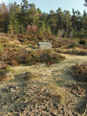
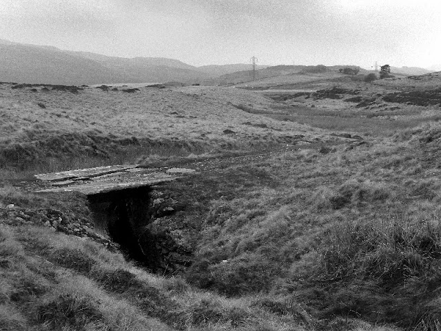
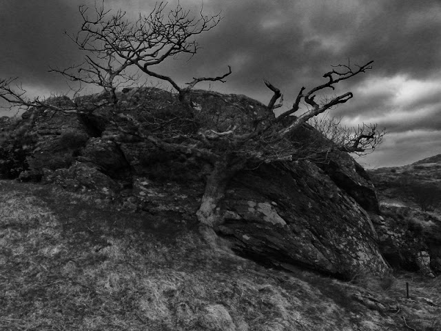
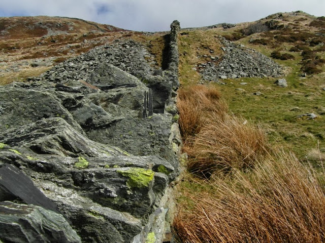
    The climb up to Rhosydd is quite a thought, especially on a dull, misty morning. But experience tells us that the place has always been worth the effort. Even in the rain, there's something magical about this mine, nestling high on a shoulder of the mighty Moelwyn Mawr. Oh, and this time we intended to capture some shots inside the fabled 9 adit.


    9 adit is a long one- at 2,221 feet it's just under half a mile, straight into the hillside. It took eight years to drive, at a gradient of 1:86; like all adits, it is arranged so that water will drain out of the mine. Completed some time between 1870 or 1871, at the same time as a big incline was also being tunnelled from floor 5 down to floor 9. (At Rhosydd, the floors are numbered downwards- one, being the highest, to 14 being the lowest.)

    I can only imagine the logistics of an operation like this, all done by surveyors measuring without 3D imaging or laser technology. When the miners driving 9 adit met the miners driving the incline tunnel, it is said that a large crowd had gathered underground to witness the breakthrough. As the rock between was blasted away, the crowd "fell like dominoes from the blast" There is no record of whether anyone was hurt..


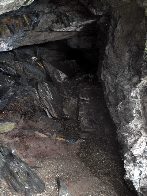
    Of course, the adit is wet, but nothing that would trouble a pair of wellingtons. We sploshed along for what seemed like ages until we came to a crosscut, where a chamber opened out. It was an attempt to work the Blaenau North Vein, reminiscent of Conglog, just a mile or so down to the North West. But the main workings were still a good many footsteps down the tunnel yet.

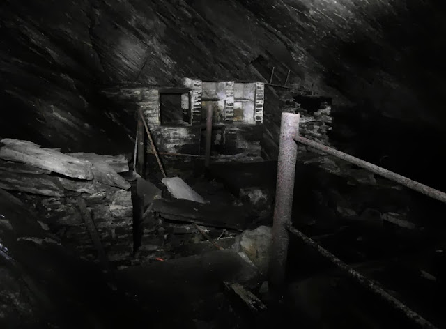
    The Compressor Alcove


    After more sploshing, an alcove opened up on the right. It was, according to Lewis and Denton*, a compressor room, where in 1921 a machine was installed by Broom & Wade to provide air for drills working the then newly opened back vein workings. The compressor itself was driven by water, from a reservoir higher up the hill above at Cwmcorsiog. Much use was made of water power within the mine, and occasionally we could see the remains of the 6" main pipes that had transported it- although most had fallen victim to the scrap man, even at this inaccessible spot.

    The Crosscut gallery
    Shortly after the compressor room another crosscut came into view, leading to three large chambers. They are very difficult to light and my photographs didn't do them justice. Petra was far too busy taking her own photographs to become a model for scale, so they went unrecorded by my camera - you'll just have to take my word for it that they were very fine!

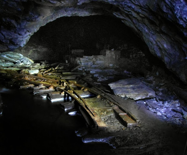
    First view of Piccadilly Circus


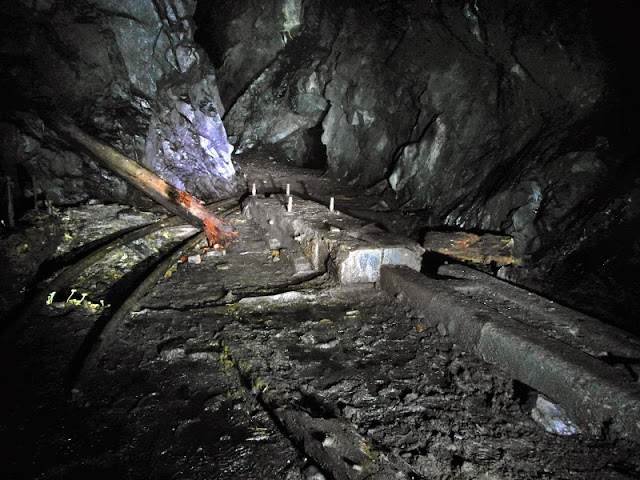
    Finally, we reached the large, low chamber known as "Piccadilly Circus", the transport hub of the mine. Here an incline went up to floor 5 and another down to floor 14. Level 9 was where all the traffic for the mine was marshalled and sent out to the mill, using a continuous haulage system. It was laid as three rails, branching out into double-track at a  passing place halfway down the adit.


    We found the base of the 5-9 incline where an ingenious system had been in use. A large trolley car (called a Trwnc) was fitted to take a number of waggons and rolled up and down the incline on large wheels at a gauge of 4'8.5". It was counterbalanced by a truck which ingeniously passed underneath the cradle, called the Mochyn, ("pig" in English). This ran on rails at a narrower gauge of 2' 8". It must have been a curious sight as the little mochyn scuttled underneath the 
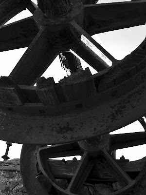
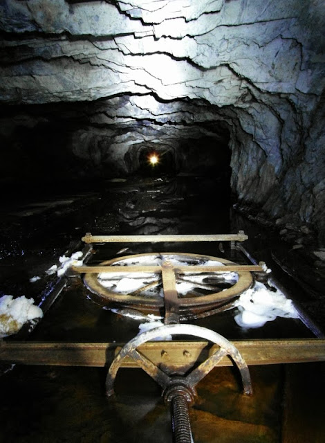
Trwnc! But the Heath Robinson theme didn't end there, as there was a further twist... where the Trwnc came to rest at the bottom of the incline bisected the entrance to a crosscut from the chambers of 9W. Some way had to be found of crossing...difficult, as this was all on the level. So the quarry engineer dreamed up a moving bridge on wheels, which slid out of the way while the Trwnc was at the foot of the incline. This ran on 6'5" gauge track. Only the wheels survive and can be seen in the photo. How I would have loved to have seen this in action!

    I am being a little uncharitable using the term "Heath Robinson" when all the inclines and their machinery and the equally clever system of water power in the mine were designed by Griffith Griffiths.  He seems like the sort of man who would have been comfortable discussing engineering with Brunel and Stephenson, yet  was "only" the Rhosydd fitter and carpenter. An indispensable gentleman, I would imagine...I hope he was well paid.

    Oxford Circus. The counterbalance incline for 9-14 rises in the background.


    The head of incline 9-14, now flooded all the way down to floor 14.
    An area slightly East of Piccadilly Circus, known as "Oxford Circus" contains The Drumhouse for the 9-14 incline as well as considerable machinery remains, from the various water powered and compressed air plants. The concrete plinths and thousands of holding down bolts tell their own story. The incline disappears down a flooded slope, 463 feet to the base of floor 14.  Another incline rises up behind the drumhouse, and this confused us for a while. Then I read that this could have been a counterbalance for the 9-14 incline, which makes sense. Why would two inclines going up be needed otherwise?

    Engine Room B9E

    The chamber A/B9E engine room, with evidence of a fall behind.

     
    After wondering at the scene, we headed east through several chambers. In two, there had been more machinery installed. The level of noise and fumes here can only be imagined as gas engines, Pelton Wheels and compressors all roared away. At various times, Hot Bulb engines and Oil Engines were installed as well as electricity generating units. Our friend Mr Griffiths must have been a very busy man. Behind one of the engine rooms, a massive fall had occurred, blocks the size of a car having fallen in a mighty jumble.

    Pointwork, looking towards Oxford Circus
     The trackwork was also of a very high standard in the mine, with pointwork made by the Ffestiniog Railway at Boston Lodge. Because of the three-rail tramway out of the mine, the double flanged wheels so common in other mines locally were entirely absent from Rhosydd, and one or two wheels were lying around underground to prove the point. I wondered if the point frogs were cast at Britannia foundry, but could see no marks. The rail is mostly T rail, 20lbs per yard. One or two chairs still remained, and I was glad they hadn't been taken by souvenir hunters.

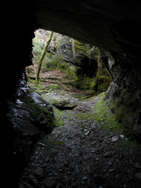
    Looking towards daylight from the 9 adit sheave winder.
    The mine is a fascinating place and we still have much to explore underground. It's popular with gung-ho explorers for the through trip that can be made from Croesor, something of a rite of passage among the mine exploring fraternity. Which is great if abseiling and underground dinghy sailing is your thing. The downside of it being a popular mine is the litter. We even found some discarded batteries in the water near Piccadilly Circus. Maybe I am being too fussy, perhaps it doesn't matter to most folk, but it spoils the magic a little for me.

    I don't want to end this post on a sour note, so I will just say that Rhosydd is rightly one of my favourite locations...the mine and it's setting are spectacular while underground it is evocative and interesting (as well as having some of the most worryingly dodgy ceilings I have seen!) Coming back down the track to Cwmorthin is character building, especially if you have knees like mine that have been damaged by a lifetime of adventuring. But it's all worth it.

    *The best authority on the mine is the long out of print Lewis and Denton tome, "Rhosydd Slate Quarry". Copies sometimes come up on Ebay or from specialist booksellers.

    At the foot of the 5-9 incline.


    Looking up to floor 6 from the base of the 9-14 counterbalance incline.

    Unexpected Treasure: Sunday in the Badlands

    $
    0
    0


    Long suffering readers of this blog know that we have a special place in our affections for Cwt-y-Bugail, that mine peppered and punched over the rolling land between Manod Mawr and the headwaters of the Machno. We've been there so often, I kid myself that the resident pair of Ravens have begun to recognise us. But with that familiarity comes a little complacency, in me at least. I had begun to think that I'd discovered all there was to know about the place.
    The old magazine, with the mill in the background and the A-B incline to the left.
    Graffitti: carved in 1900, eight years before the big fall in the North Twll which held up production for two years.

    How wrong I was. We hadn't been at the mill for more than a few minutes when Petra found several passages of graffiti that we hadn't noticed before. One was finely carved in a door lintel, marked 1888 and it's corresponding inscription in roman numerals. Then, we climbed up to the A-B incline head to look at the old Magazine there and found some water collection ponds, probably for the manager's office, that were new to us. At this point, Petra spotted a walker making a bee-line towards us, so we headed quickly for the B floor adit and the safety of the underworld. On seeing this, our pursuer lost interest. Yes, we are a couple of miserable curmudgeons. The very cheek of it, though. Someone intruding on our mine!

    Descending the remains of B-D incline. The wal and adit can be seen near the top middle of the photo.

    Looking down on level D.
    Once in the chaos of the South twll, we mooched around, trying to visualise the incline that had once been here from level B down to level D. Petra was busy taking photos, so I looked for evidence of the junction that was supposed to have been here. There were clues in the untopped chamber. I noted a marooned platform in the gloom, with an adit entrance on the far wall...a little slate hut had been built at the entrance, Clogwyn-y-Fuwch style. Then I realised, this was the elusive remains of the Level C adit from the North twll. I had been trying to find this for years, and here it was, sort of under my nose. At which point my dim bulb brain finally worked out that if that adit was level C, then the gloomy hole below must be level D.

    We picked our way extremely carefully down the steep defile, with an even larger drop looming on our right. I realised that it was really stupid to do this without ropes, and I didn't want to trust the hand line put in by AditNow colleagues, with this exposure. From the lower section of the pitch, the chamber looked enormous. There's no safe way to access this part of the mine but at least this was one mystery solved. We climbed back up, resolving to return very soon, better equipped.

    Sheer legs crane (fallen) in chamber C4. Note the marks of a channelling machine on the wall, something else I didn't know had been used here.


    On to the North Twll, where we pottered about happily underground, photographing the remains. The two big chambers here yawn like pharaoh's tombs, mouths open to the sky. I stood for a while, savouring the atmosphere as our two Raven friends flew over, their cries and woofing wingbeats amplified strangely in the workings, as if they were flying through the adits..

    Last time we were here the water was ridiculously cold. This time I was wearing wellies (I couldn't be bothered to take the wet gear, unlike Petra)  and my toes had gone numb, but Petra had wetsocks and even she was beginning to get cold...what is it about this place? I sploshed about at the end of Chamber 2, noting the rather worrying ochre filled shaft. As I stood there contemplating this feature, I became aware of a low opening in the rock further in the gloom at the back of the chamber. Of course...C adit north! Why had I never seen it before?  I crawled in and then immediately found myself almost over critical welly depth. I could see rails underneath, and prodding with the trusty camera tripod, made sure it was safe. I went back for my partner in crime.

    Level C North/West
    Level C West
    Petra made her way in as the water rose gradually up to thigh level. Having a ninja missus is humbling sometimes.  I didn't fancy getting wet wellies, as it was a mile long walk steadily uphill to the Bwlch-y-Slaters car park, so I stayed put like a jibbering  feartie.  I listened enviously as she sploshed along. She  knew all about the hidden shaft in the first chamber, lurking under the water, (thanks, Barney) so I wasn't too worried. I almost walked in behind her, but remembered what it felt like afterwards when I did that at Bwlch-y-Plwm...and there the car was parked almost at the adit! After ten minutes, she returned, smiling happily. Another bit of new ground, and a fab set of photos. She says I have to go and take my own...


    Pretty satisfied with our exploring,  we climbed up to the old engine winder at the top of the incline out of the pit and did a round of the North Twll, enjoying the stunning views to Snowdon. As usual, the ravens accompanied us away from the mine, their burbling croaks setting the seal on a pluperfect day. I realised that no matter how many times I return, or study the books and the old maps, I'll always find something to delight me up on the badlands. So watch this space for the next instalment, when hopefully, we will reveal the secrets of the elusive level D chambers.


    I've just noted that JAW's excellent "Remains of the Welsh Slate Industry" site has been updated. There's a fine section on Cwt-y-Bugail, highly recommended!


    A stroll around the Penmachno Hills, with quarries.

    $
    0
    0


    Google Earth is all very well if, like Petra, you know what to look for. It can be invaluable in finding old mines and quarry sites. A suspicious depression in the terrain, a tell-tale, delta-like tip or signs of a tramway- these things all get the mine senses working. A quick cross check with Wilkinson's Gazetteer of North Wales mines, and an expedition might well be afoot.

    I generally prefer to use "Where's the Path" because you can compare the map terrain with the satellite data side by side. They do grid references, too. For someone brought up with the OS these are much preferable to the co-ordinates Google uses. But if you ask me, the real trouble with Google Earth is that, if you use it alone, you will have little idea of the severity or otherwise of the terrain.

    This Penmachno trip was a case in point. I was recovering from the unwelcome effects of a cycling injury, (trying to use my knee and hip as an impromptu brake) and we'd both been too busy in work to plan any adventures. So when this one was mentioned, I heard "quarry" and immediately looked up from my elevenses to give a thumbs up. Petra printed out the route (a great feature on Google Earth) and before I had time to make another sandwich, we were in Penmachno.

    The drive to the village is beautiful in any weather, but in early spring when we visited, it is near to perfect. We walked through the streets with their fabulous old houses, many of which seem to have been shops at one time or another. The buildings here have real character. We started from a small farm road which leaves Yspytty Road at SH 79120 50476. The track goes along for half a mile until some fine old buildings come into view.


    The impressive barn here is a grade II listed structure dating from the C17th and uses massive blocks of rustic slate. There is a beautiful old Manor House, again C17th. (Coflein)
    This is Hafod Dwyryd, and besides being a lovely spot, is also the first quarry on the walk. There were some intriguing remains of slate built structures and a loading bank. Meanwhile in the woods, a deep pit loomed. There doesn't look to have been any underground activity, but Richards* states that waterpower might have been used. The pit was very well fenced off, but is obviously the source for much of the blocks of slate used in the barn.

    
    Hafod Dwyryd quarry buildings.


    A 1950's road sign used as a fencepost.

    We carried on uphill, with views south opening up, better all the time. The road, though, became steadily more rutted and unkempt, until we came to a dog's leg curve at SH 7935 4764. This was near to where Petra thought that the Afon Oernant mine was to be found. We carried on following the stream until the road gave out, and then repaired to the undergrowth. The ground was steep and boggy here, but after a slightly sportif ford of the stream we found a couple of feint, run-in adits. That's definitely what they were, but only a mine enthusiast would be able to tell!

    
    The Afon Oernant Adit.
    Looking South to Cwm Penmachno and Rhiwfachno Quarry.
    Buoyed up by finding two mine sites, we decided to head for the Llechwedd Oernant quarry; on the Google printout, it was but an easy stride from where we were. In the real world, a great many contour lines lay between us and the quarry, and they were all very close together. We strode upwards through the energy sapping heather and eventually made the ridge, where something like a low wall could be seen half a mile away. The air was fantastic and the sounds of curlews and moorland birds crackled around us. This felt very remote. From the top of the plateau there isn't much of a view, but when we made it to the quarry, a breathtaking panorama opened up. I rested on the wal, (a wall-like low shelter to protect quarrymen from the weather) as my knee was really rather painful now.


    Not much to say about Llechwedd Oernant except that it is a stunning location with a shallow, flooded pit. I can't imagine much product was had from here, let alone carted away. It's at SH 7867 4749. The wal is handy. We'd planned to go further south onto the ridge to eyeball another quarry, but the climb had winded us; we were paying for working all those long hours without taking proper exercise. Petra plotted a route down to the machno valley, which would be the shortest way off the ridge and on to a metalled road. It did take in another quarry, of course.

    Climbing up...at this point, Llyn Conwy is just a couple of miles over that ridge.


    The ground was very difficult, heather and hidden gopher holes abounded, with boggy interludes. Then a barbed wire fence, which we crossed at a corner post to avoid damaging the wire (and ourselves). I was giving a good impression of Spotty Dog from the Wooden Tops by now as my injured knee had decided that bending wasn't an option. Never mind, a quarry was in sight. It was an unpleasant and difficult tramp down and I have to admit that I didn't have the chutzpah to climb over another fence and go and see the remains of  the various fascinating excavations at Pen-y-Bedw. There was one wonderful moment, though, when I spotted a beautiful round powder house, almost submerged in the undergrowth. Another time, perhaps.

    
    The ruined Powder Magazine
    Now, our route took us steeply down on a tractor-rutted track to a farm and I was a little uneasy about trespassing. We would be the last people to do any damage, but the farmer wasn't to know that. I also felt pretty stupid, limping along from mole hill to mole hill. We needn't have worried, the farmer seemed very pleasant although obviously thought us pobl gwallgo . The feeling of relief as my boots felt tarmac was rather fine...I don't normally like walking on roads, but this was la guerre and an expedient moment. Petra's routefinding was spot-on, even if the volume of the hills and depth of the bogs was unexpected. But then, this is Wales and whatever else I might say, this was an adventure. The knee is a lot better now, but I was a bit sore for a few days...

    Spotty Dog  makes an appearance in this video at 6.20.

    There are over sixty listed buildings in Bro Machno. So many gems!

    Dilwyn Evans' wonderful models and histories of Siopau Bro Machno.

    *Alun John Richards "Gazeteer of Slate Quarrying in Wales " Gwasg Carreg Gwalch


    A New Look...

    $
    0
    0
    Where to now, boss? Adventure, of course! The statue of Master Mariner and Lifeboat supremo Dic Evans at Moelfre , Anglesey
    No, not a purveyor of reasonably priced ladies wear, but a new look to the blog. Petra very kindly gave it a makeover and to celebrate, I have trawled the scrobiculate recesses of my hard disks and cobbled together a selection of previously unseen photographs, from expeditions that didn't quite yield enough for a blog post, but were too interesting not to use. Hope you like 'em ...and the makeover, too.

    I wonder if I should tell you where this is, or let you guess? It's on Anglesey and it's a slate mine...look closely and you can see steps cut into the rock.
    Remains of a jetty from the Ty'n Towyn microgranite mine, near Llanbedrog. The incline can be seen in the background.

    One of my favourite shots from the Craig-y-Fron Limestone Mine near Bala.
    The "River of Slate", Blaenau Ffestiniog.
    Conglog Slate Mine

    Nant Gadwen Manganese Mine

    $
    0
    0
     
    This fascinating mine lies in an isolated spot on the Llŷn Peninsula near Rhiw. The area is something of a manganese mining hotspot, being near to the famous Benallt Mine as well as other less illustrious concerns. Today, it takes the mine explorer's "eye of faith" to see the mines...but scratch the surface and with a little imagination, history comes quickly to life again.


    It's on a popular path down to the attractive beaches of  Porth Ysgo and Porth Cadlan, as well as lying on the North Wales Coastal Path. As a result, there's a well beaten track down, which is welcome and makes a change from walking miles uphill through heather and bog! We found the adits easily, as well as a large openwork, filled with discarded car body parts and other dubious rubbish. This area didn't seem to be connected to the lower levels, although there are many marooned adits underground which might prove otherwise if it were possible to explore them.


    The site reminded me a little of Porthgain in Pembrokeshire, or maybe it's just the idea of a mine next to the sea. It has a fascinating history and a special atmosphere. Despite only being an hour's drive from our home, it felt as if we had travelled a great distance to somewhere very different than the looming slate tips of sunny Blaenau Ffestiniog.

    Down the rabbit hole! Adventure begins...
    After mooching around in a couple of small, trial adits, we found the "Injan adit" and readied the cameras, torches, helmets and tripods, while garnering incredulous looks from walkers passing by. That was certainly one thing we didn't like about the mine; we don't like being "tutted" at for going underground. Not that the folk in their co-ordinated strolling gear would venture where we were going. It feels good, though-to have a hobby that is shared by only a couple of hundred other folk in Wales.
     

    The adit opened quickly out into a large underground cavern, stoped up to a considerable height, with cut-off tunnels and chambers above. Descending again took us to a lower area with machine bases and rails going off to eventually emerge on the surface again. Flooded levels loomed, with a set of rails descending on an incline. The mine was dewatered in the forties, with hopes of revival; these came to nothing, but it would have been fascinating to have seen the lower chambers. The adits are flooded, one at least to above critical welly level, but it's not too far to walk back to the car with boots full of mine water, for once!

    Weigh house at the top of the Jetty Incline
     Above ground, the remains are fascinating. There is a top level with a fine drumhouse and behind it, an engine shed with a pit and room for two locos. The views from the incline are very fine, looking out towards the Ynys Gwlans and Pen Cil on the Llŷn mainland. Looking at the old photos on the Rhiw site, it's not difficult to imagine the place as it was in the peak of production.
     
    A big thank you goes to Ian Adams, for pointing us towards this mine.


    Nant Gadwen Factoids and links

    Nant Gadwen mine was opened in 1827...two years later, the mine's output was recorded at 226 tons. At first, the heavy ore was taken away on the backs of mules to any port where a ship could be persuaded to dock - the coast hereabouts has a reputation among mariners and the proximity of Hell's Mouth was not an attractive incentive. Later, an incline was built down to a jetty, constructed in 1902/3 at a cost of £182. 

    In 1918, five ships a week were calling at the jetty.


    The peak of production was in 1906, when 10,000 tons of ore were sent away to Brymbo and other iron and steel centres.

    Nant Gadwen produced 45.644 tons of manganese in its lifespan.

     For some reason, there were several gauges of rail used here, the main one being two foot gauge, although three foot ruled on the inclines. It is possible that there was mixed-gauge track in the stockyard above the final incline to the jetty. At least one steam locomotive is known to have worked here, a purpose built 0-4-0 saddle tank by Bagnalls of Stafford, called "Rhiw".

    Production declined in peacetime because the ore was not of the highest quality, and superior foreign ores could be sourced by the mine's customers.

    The mine shut down for the last time on Monday 17th August 1925 and the jetty was demolished in 1933. Rusted remains of the winches and incline pulleys can still be found on the beach below.

    The Steam Ship " Daisy" loaded 340 tons of manganese ore on Monday 11th July 1927. This could have been the last ship to load at the Porth Ysgo jetty. Presumably this was ore that had been stockpiled in the yard; there are still piles of it there today

    The mine is located at SH 211 266

    Excellent account of the mine by Alan Clogwyn at Mine-Explorer

    Rhiw.com...an invaluable source of information about Rhiw and it's surrounding countryside.

    Photos of the site at Geograph.com here.


    An overall view over the old engine shed, looking towards an old Iron Pyrites mine that was incorporated into the workings.


    Viewing all 103 articles
    Browse latest View live