Quantcast
Channel: Treasure Maps
Viewing all 103 articles
Browse latest View live

Mines of the Afon Lledr

$
0
0


We have wanted to look at these mines for many years, but were always put off by the inhospitable terrain.  The thought of slogging for hours only to find a few scrapings on the ground didn't seem a sensible pursuit. So what had changed our minds?  Well, we had been exploring the mountains around the Lledr Valley and found that it was quite possible to make good progress by sticking to the tops and flanks of the peaks. Coming from the Crimea pass, it's possible to get a good start by using the Tunnel road to the ventilation shaft workings. The trouble is, most of the mines are at the bottom of valleys.


After a lot of map study, we elected to go up from the Hendre Coed slate mine, following the river all the way up. (SH69655 51231)  It wasn't too bad initially, as a farm road goes for a few hundred yards. We crossed the river at the old bridge, finding the tracks of the farmer's quad bike also went our way...so far, so good. Incidentally, this bridge and the ruined buildings around it (SH68701 50298) seem to be shrouded in mystery. Geograph states that they belonged to the Moel Fleddiau slate mine...really? Since that mine lies on the bwlch between the Lledr watershed and Allt Fawr, and it is a short step to Blaenau ( a rather precipitous one, admittedly) I have my doubts...surely the mule track over Bwlch-y-Moch would be more reasonable. At any rate, on the OS 1888 map, bridge and buildings are referred to as Cwm Fanhadlog Uchaf and on the modern series, Cwm Fynhadog Uchaf .

The bridge over the Lledr by Cwm Fynhadog Uchaf, clearly of some antiquity.
One of the structures has the look of a chapel about it...I came this way several years ago and took photos but can't remember if there were any gravestones...this time the bracken was too high for exploration, but perhaps this was a chapel for the workers on the tunnel? Across and further up the hillside above the bridge is a powder house for the tunnel.

Moel Siabod glimpsed behind the mystery building at Cwm Fynhadog Uchaf.
We walked on. I was wearing a brand-new pair of boots and they were performing well, my last ones having disintegrated due to constant soakings. We came to a flat area where the pasture resembled a prairie, and here, the quad bike trail ended. Now the ground ramped up and became much more inhospitable. To describe the rest of the walk I can do no better than to quote the Walk Highlands web site, which states:

"following the river up the valley is probably the wettest stretch of walking imaginable, a long, long slog of waist-high reeds hiding knee-deep watery marsh…"

That's the one. If someone had been watching as we stumbled and slipped from one bog to the next, or pratfalled countless times, they would have been highly entertained. Gaining height simply changed the predominant vegetation to chin-high ferns, but still with the knee deep bog and with the added delight of sheep ticks. Every now and then, a rock outcrop was encountered, providing a welcome respite from the bog-bumping and falling over.


Petra spotted a small building, not immediately visible on Google Earth, right beside the river. It was a wal, with a modest waste tip alongside. (SH68112 49396) The small excavation went into an outcrop beside the river and must have been a trial. It made a nice photo, but it seems to have escaped the cartographers, as it is not marked on any map or survey, including the OS 1880 from the NLS.

However, we were emboldened now. Despite our pitifully slow progress, I reckoned we would be at the Afon Lledr mine in 35 mins. The next half mile was the longest and most painful of my life, but we made it. Perhaps it would have been easier in the winter, when the vegetation is not so high and the ground frozen...who knows.

The Afon Lledr spoil heaps.
The site of the mine is a very interesting one, comprising two possible concerns. The original Afon Lledr mine is nominally copper, and crosses the stream to a low adit, flooded to the ceiling and with deadly silt in the entrance. This would appear to date from the early to mid C19th as again there is no record of it being other than disused on the 1880 OS survey. The waste tips contain some fine chumks of quartz and galena. The mine is at SH67559 49299.

The Lower Adit
Further upstream there are some ruined buildings and three opencuts, plus a flooded shaft. The buildings are a fine range and as far as I can tell, comprise a forge, a barracks and an office. Processing seems to have gone on in the open air. The first opencut goes west, then turns at right angles upon encountering the lode. A fairly deadly-looking winze chases the lode further and lower.

Remains of the forge
 Another opencut is worked above and finally at the top of the outcrop, there is an opencut with a flooded shaft.  As far as I can tell, these are the workings of the Moel Fleiddiau lead mine, although all the mines here are thus marked on the OS.

The processing area and office at Afon Lledr.
 By now, the sun was due west and photography was difficult from some angles, hence my photographs of the workings are not as fine as I would have liked. However, this is a fascinating spot, well worth the crippling walk. We found no sign of the features in the stream that David Bick writes about in his "Copper Mines of Snowdonia" although the mine fits the bill in every other respect. And the new boots? They are still drying out.

The winze.
Further reading: "The Old Copper Mines of Snowdonia" by David Bick, ISBN 0 906885 03 5

The Llyn-y-Gadair Slate Quarry

$
0
0

Thanks to the relatively new Lôn Gwyrfai path, running for for 4.5 miles between Rhyd Ddu and Beddgelert, this quarry is very easy to access. Starting at the Rhyd Ddu car park by the WHR Station, the path skirts the lake, the first few hundred yards along the trackbed of an old tramway.

The path is new and raw, and has all the hallmarks of "best practice" with it's railings and stone supports along the way. The young Afon Gwyrfai is crossed in fine style with an oak and stone bridge. Every now and then there are impressive stone buttresses to hold gates...substantial ones, as this is a multi-use route for horse riders as well as cyclists, ordinary footsloggers...and slate mine enthusiasts. There are even carefully made mounting blocks for the horse riders. Well, if you are going to build something, better build it properly.

The magazine, with the tips of Llyn-y-Gadair in the background. Y Garn and Mynydd Drws y Coed rise up on the Nantlle ridge behind.
 So in no time at all, we were striding across the lower slopes of Y Garn, looking at the remains of what seemed to be a Nantlle style operation with an incline going down into the flooded pit. One of the good things about the new path is that it hasn't sanitised any of the remains and picks it's way through them. (Have a look at JAW's excellent "Remains of the Slate Industry" site here for some photos taken pre-path.)


The pit has various massive, well-built structures above it, mostly for the capture and storage of water. Two wheel pits lie here, possibly to power the haulage incline and machinery at the mill, once sited on the flat area to the side of the incline. The mill was demolished- possibly when  the quarry to the east came into production. From here, you can see the line of an old tramway which took spoil to tip into the lake. This has in turn been built over by the exit tramway from the eastern operations.

The Blacksmith's shop for the Gader Wyllt quarry to the east. A pair of substantial gates on the path can be seen to the left.
The site, while nominally called "Llyn-y-Gadair" is actually a collection of several concerns: Drwsycoed, Gader, Gader Wyllt and Hafoddruffydd. Looking at the NLS maps, the oldest, 1888, has this first pit working as "Llyn-y-Gadair". It was possibly worked out by the time the next concern, "Gader Wyllt" started up to the East. Certainly, Llyn-y-Gadair had ceased operations by 1890, as the HM inspectorate records show. There are records of a machinery dealer selling some of the rails to a quarry in Nantlle during 1897.

Gader Wyllt incline head and drumhouse.
 Gader Wyllt lies to the East, on higher ground. The mill here may use beams possibly from the demolished mill at L-y-G. There's also a ruined machinery room to the western side which would have housed some sort of engine. A line of Hudson track goes northwards towards an incline head and drum house- this is pretty much destroyed by the elements, while some primitive walliau snuggle beneath the level of the tip in a slightly more protected spot. These might have been a later addition, used by men working the tips during the 1930's depression.


 A pit lies behind the mill; it was impossible to see if there was an adit due to the vegetation and extremely boggy nature of the ground, although one is mentioned in Jones and Richards*.  Below, nearer the lake, the foundations of the newer, unfinished mill stand, a quixotic monument to a failed enterprise. Ownership of both quarries is a tangled skein, even by North Wales standards. The HM Inspectorate doesn't list this quarry until 1913, although according to the maps, it was working in 1888.  With the Lyn-y-Gadair quarries in general, various complicated plots emerge, involving among others, the North Wales Unionists Quarries, Cadwallader Humphreys, manager of the defunct Glanrafon quarry and even the famous (infamous?) J H Robinson of Nantlle at one point, until the Gadair Wyllt concern finally ceases in 1928. The interlinked story of the personalities and organisations concerned is a complicated one and too involved to go into here, but it is worth noting that while the Unionists Quarries company didn't come out of things too well, Humphreys bought the Quarry freehold for £2000 in 1924 and a year later sold the land to the Forestry Commission, minus the quarries, for £5000!

The Gader Wyllt mill and pit, with the primitive walliau beside the track on the left.
Going back to the topography, a well-engineered tramway goes off to the East towards a small working, with a weigh hut and an adit, much overgrown and choked with weeds. This is likely to be a trial working only, as there is not a great deal of spoil. Another trial also lies further Eastwards.


The trial adit and ruined weigh house.
Finally, there is a pit behind the unfinished mill, perhaps an earlier excavation, again it was too wet to explore very closely. Scattered around the site are many glacial erratics, left after the last ice age, when the boulder clay that overlies the slate here was laid down. Interestingly, one of the first prospectuses for the Llyn-y-Gader quarry points out the reserves of "fireclay" and an early lessee was Frederick Wallis of Kettering, a brick and tile merchant. However, there is no evidence that any clay was quarried here.

The mystery of the development of this site, like the machinations of the various lessees, will never be solved- but I can't think of many sites so easy or pleasant to access. In good weather it makes an easy trip out, with the added bonus of WHR trains passing across the valley. Of course, when we visited there were none, although the Snowdon Mountain Railway train could very clearly be heard chuffing up to the summit!

The remains of the new mill, unfinished at the time of abandonment.

* "Cwm Gwyrfai, the Quarries of the North Wales Narrow Gauge and the Welsh Highland Railways", Gwynfor Pierce Jones and Alun John Richards, Gwasg Carreg Gwalch, 0-86381-897-8

Lôn Gwyrfai path link.


Pen y Ffridd or Llanrhychwyn Slate Mine

$
0
0


Pen-y-Fridd has to be one of the most enchanting mines that I have ever visited. The daylit chambers open out into the woods near Trefriw at SH776612 and in some ways, feel a little like Clogwyn-y-Fuwch, but on a smaller, more intimate scale. A series of openings follow the vein along a dolerite sill, but the adjoining walls are worked away, so that only the pillars remain to hold the roof up.  It's a wonder that the whole place hasn't collapsed before now, but the result is a cathedral-like space, quiet and eerie in the woodlands.

We first visited a few years ago, but In a silly moment, I accidentally deleted all my photographs before I could process them. Petra and I have been meaning to come back for a long time...finally, this spring, we made it. Nothing much seems to have changed. You can still park in a lay-by along from the footpath entrance that leads to the mine, walking along through a farm and shortly afterwards taking the right fork up a steepish path that leads to the workings. This felt like hard going for me as I was carrying my excessively heavy tripod and underground kit, but the wonderful woodland setting made up for the discomfort.

It is an old mine. The first record of it is in 1786, when Pen y Ffridd slates were known to have been exported from Conwy. The slate is black and quite heavy with pyrites, liable to rust and crumble when exposed on a roof, but nevertheless, the mine kept up a good trade and between 1824 and 1840 it mainained an output of over 1000 tons a year. Output carried on spasmodically until it was last worked in 1865.


Walking up to the mine, you are aware of the tips on the left, so overgrown with trees and vegetation now as to be barely recognisable, looking more like river spurs or ridges. There may or may not be an incline, there certainly is a little bridge at one point. The records are coy about whether there were any tramways here, perhaps this was too early...we certainly didn't see any evidence of rails. Output seems to have been processed outside, with no signs of walliau or a mill, although the smithy is marked on the 1899 map. The smithy is a magical place and I spent some time trying to photograph it, although the encroaching trees nearly defeated me.


Getting in to the mine is a struggle, involving clambering over fallen timber and dense undergrowth. The path is well fenced off, too, being a public right of way, so barbed wire has to be negotiated. It's all worth it, though as the place really is breathtakingly beautiful. It is, as Williams and Lewis* say, an "eerie and mysterious place".


This time, we walked up to the top of the workings and found some scratchings and remains of workings on the highest level. I doubt whether this would have been a powder store as I wonder whether powder was used at all- I suspect the slate was hammered and crowbarred away from the gangue rock.


There are also run-in hints of lead mines in the vicinity, quite subtle and only seen with the mine explorer's eye of faith...a tip here, a depression there. It does add up to a picture of the place being very busy at the end of the C18. A new road was built in 1824 by Robert Hughes to take produce to the quay at Trefriw and there are some references to slate workers sawing blocks and splitting slabs on the quayside for onward distribution down the River Conwy.

"Gwydir Slate Quarries, Williams and Lewis, Gwasg Dwyfor, ISBN 0 9512373 5 7


Craig y Penmaen Copper Mine

$
0
0
In the Opencut
Earlier this year, we spent a lot of time exploring the area East of the A470 near Bronaber.  It seems at first to be a beautiful, but uninteresting slice of Wales until you begin to scratch the surface. Then, as always, fascinating things begin to emerge.
We were mine-hunting, of course- and uncovered a few gems, which hopefully will appear here soon. We also discovered that the area had enjoyed a very different life from the role of  holiday village that it mostly assumes nowadays. What we thought had been quarry buildings soon revealed themselves to have a rather more warlike aspect, helped by the notices here and there, warning walkers to keep to the path if they valued their limbs.  All this was, of course, in the past...Bronaber camp itself is well documented and was at it's peak in the two world wars, closing in the late fifties, when it had a brief period of glory housing the workers for the nuclear power station at Trawsfynydd. It's an interesting subject, and I may return to it sometime.


So, we weren't thinking much about unexploded bombs when we set off, up an unsurfaced track into one of the wilder corners of this area.  But, after a while, we noticed a burnt out area near the track , covered with slag.  For some crazy reason,  I thought it might be the site of a bloomery, although why, up here miles away from nowhere, I don't know. Once I had recovered from this aberration and started thinking sensibly, another, equally bizarre conclusion was the only one that seemed plausible. There was a fair quantity of molten steel which had melted into the ground and assumed the shape of the soil beneath it. Picking these rusted  pieces of steel up I noticed how very heavy they were...the only metal  this heavy, apart from lead, was some manganese steel I had tried to pick up at the shipyard, many moons ago. Scattered around were lumps of molten material like furnace slag, interspersed with hundreds of fuse bodies, shell cases, washers and other less obvious bits and pieces. I can only assume that an explosion had taken place, perhaps a large quantity of ordnance had gone off, and the resultant white heat of the concentrated blaze had vitrified the rock and melted the steel of the containers. Just a theory, of course, and if anyone knows otherwise, please let me know! I can only imagine the cost to the taxpayer of all that ordnance going bang, although I guess they were going to shoot it anyway. The other mystery is that the site was still bare of grass, presumably since the fifties?

The Dol Gain Copper Trial.
Suitably mystified, we continued on our way...and this was where more confusion began.  We were looking for a copper mine on the side of Craig y Penmaen, an outlier of Mynydd Bach. According to the Ordnance survey there were several excavations on the west side and Jeremy Wilkinson's excellent and normally infallible gazetteer notes them too. Looking on Google earth turned up a mine, but ...not in the right place. Looking back on the 1891 OS gave the same result as the gazetteer. Then, there was another mine which Petra spotted as we were stumping along, the Dol Gain Copper Mine, although the maps do have this one in the right place. The three mystery mines on the map are the Craig Penmaen East, West and South mines, although we couldn't find West and South.

Looking out from the Opencut
We eventually made it to what I assume is the East mine, to find a fine entrance opencut, a set of steps from a stile having been pressed into service to access the main adit. It's a lovely spot and the bosky entrance disguises the size of the excavation. Once in the mine, the drive goes along for a while and then twists to meet a roofing shaft. Above us we could see a  false floor, wooden boards straining with the weight of deads from above. It looked precarious and dangerous, so we didn't linger underneath it. Further investigation outside revealed a large stoped area on the hillside above, full of deads. None of this was on the OS maps, either historic or modern. A bit of a mystery, as the OS are usually so accurate. We had a good look around and there was no sign of the other mines marked...I wonder if an overlay had slipped back in 1891 when the cartographer had gone to lunch and he didn't notice it upon his return? The mine was nicely decorated with copper staining and fairly dry, although I don't think anyone without "miners eyes" would notice it. For us, the chalcopyrites in the wall gave the game away, as the adit is not visible from the trackway.

Copper leaching from the walls of the adit.


Petra's photo of filamentous fungus growing on a dead moth in the mine. https://mydododied.tumblr.com/
 We doubled back down the track, which is a bridleway, I should mention- to where Petra had spotted the other adit. It was a climb back to the foot of Craig y Penmaen and over a wall, then into a dip. The adit was a fine one, although entering was a huge disappointment as it turned out to be only a trial. Curiously, it drove both North and South immediately after the portal, similar to the Afon Gamallt mine.
The trek back to the road was wonderful, the views across to the Moelwyns in the distance the stuff of postcards and amateur watercolours. If only James Dickson Innes had come a little further West from the Arenigs and painted here. Skylarks were singing, too- and Petra noted the odd fact that when they are climbing, the song goes up...when they are descending the song goes down...
One last thing occurred to me as we walked back. Surely if ammunition had exploded, there would be a crater, and a wider area of damage? I am mystified!


Keith O'Brien's collection of old photographs of the military camp here

Petra's Tumblr

A Blast from the Past: Dol-y-Clochydd

$
0
0

A little while ago, a friend mentioned to me about an ancient blast furnace near Ganllwyd. This gentleman is a very knowledgeable and precise fellow, not given to flights of fancy, so I felt that I had to go and look.  I couldn't imagine a blast furnace in such a beautiful spot; my mind would insist on conjuring up images of the old John Summers works in Shotton, or the furnaces at Port Talbot. What I found surprised me.
The story starts back in the first half of the C16, when it is known that a bloomery was sited at the Dol-y-Clochydd site. What is a bloomery?  It is the site of a small-scale iron furnace, where iron ore is heated and reduced to form iron-rich slag. This slag or "bloom" is heated  then reduced again by hammering the waste, or gangue, away repeatedly until finally a reasonably pure iron bar (wrought iron) is produced. There are still many impurities such as phosphorus, nickel and arsenic which are partly reduced to the iron, leading to some interesting alloys. One thing all this heating needs, though,  is a great deal of fuel. Charcoal.
Enter the first notable player in our story, Hugh Nanney, whose increasing status in 1586 as Sherrif of Meirioneth allowed him to acquire a great deal of land, including some of the lands belonging to Cymer Abbey. Dol-y-Clochydd was situated in one of these parcels and he wasted little time in leasing the furnace off to a couple of English fellows,  John Smith and William Dale . The deal was sweetened by including " all the trees on Penrhos Common, a low hill to the north, adjoining the said iron mill’ Here's a thing- you might be wondering why there was all this iron activity here, of all places- perhaps there were deposits of iron ore? After all, there were a number of other bloomeries operating at the same time in Coed y Brenin.  There were iron deposits on the slopes of Cadair Idris, and further up the mawddach valley, but, no...the crucial factor was the availability of timber in large stands of trees. Oak, that is, not the monotonous Sitka that pervades the area today. In a post-Elizabethan England where most handy timber had been used to build ships, resources were scattered in less convenient places, such as the upper Mawddach valley, although that still isn't quite all the story, as we shall see.
So, our Englishmen lost no time in cutting down a great deal of timber to make charcoal However, Hugh Nanney was either unscrupulous or careless, as it quickly came to the attention of the Crown that these woodlands were being decimated, and they sent a deputation to Nanney to serve a notice of theft on him- it turned out that the trees on Penrhos common belonged to them! The hapless Nanney was fined £1200 and sentenced to two years in the Fleet prison; it couldn't have been a comfortable billet. The fine was later reduced to £800 after the quality of the wood was disputed...it was decided that Nanney's tenants had taken 10,000 oaks at a cost of 3 shillings each, but a carpenter, brought to give evidence by John Smith, claimed that many of the oaks were unsuitable, and that the wood was difficult to extract from the steep hillsides.
Nanney didn't seem to be ruined by his spell at her majesty's pleasure, because soon afterwards, he was back on the scene. In 1596, he is brokering a deal to convert the site at Dol-y-Clochydd into a blast furnace, bringing William Grosvenor on the scene as a financial backer. By this time, Smith and Dale had taken out a new 21 year lease on the site. Sadly the new furnace only had a short life and it is reported to have been blown out by 1604, although this may have been because of a scarcity of wood to use as fuel- certainly, nobody would be thinking of taking timber from Penrhos common....
Coming back again to the question of why these men had developed the furnace in such an out-of the way spot; granted, the wood was a factor. But Nanney was a something of an entrepreneur, and despite his new status as an ex-jailbird, had many influential friends at court.  For instance, he was patronised by Sir James Croft, formerly Lord Deputy of Ireland and Comptroller of the Royal Household under Elizabeth. The aforementioned William Grosvenor, one of the backers of the project, had forges and warehouses in Chester, for the supply of arms for use in Ireland- so perhaps Nanney was making use of what was available to him locally at the time and using his contacts to find a market for his iron. What happened to Nanney, Smith and Dale afterwards is probably an interesting story, but for now, let's take a look at the site as it is today.


The furnace lies near the bank of the Mawddach at the foot of a very steep slope, which has probably contributed to it's survival, as it is difficult to access the place with agricultural machinery. We stopped our truck at the side of the road while I squinted down to the river banks, not quite knowing what to look for. Then, I saw it. Nothing more than a low, squarish mound, but undoubtedly something worthy of investigation.  We scrambled and stumbled down, slipping and then sinking ankle deep in mud, but soon we were at close quarters with a furnace that was last blown in 1604. I was quite excited to finally see this, after reading about it beforehand. It was excavated by a team of archaeologists in the 1980's, firstly by a group from Plas Tan-y-Bwlch who found evidence of "glassy blast furnace slag in the riverbank" and latterly by Peter Crew who has made a definitive study of the subject, referenced at the end.


There are the feint remains of a loading bank, or charging platform. The wood posts at each corner are obviously relatively new, but mark the king posts which would have supported a wooden structure around the furnace. The blowing arch can just be made out, with its sandstone lintel, while the lining of the furnace shows signs of sandstone blocks, vitrified by the intense heat. It is certainly a lesson in industrial archaeology brought to life with the help of a little imagination. Grass has grown over all the excavations, but in the 80's, signs of a casting floor were found and evidence of a water powered bellows. Today there are remains at the top of the bank of a stone built ore hopper where iron ore and bloomery slag would be offloaded from the road and sent down a chute to the furnace. It's not hard to imagine the activity and smoke here back in the very early C17.

I would like to apologise for the poor quality of the photos, it was a very dull and drizzly early spring day when we visited and no amount of C21 technology can quite make up for the lack of sunlight!

By the way, Dol-y-Clochydd means "the Sexton's Meadow".

Dol-y-Clochydd blast furnace, grid reference SH 734 220

P. Crew and M. Williams. "Early iron production in north-west Wales". In Medieval Iron in Society II. Stockholm: Jernkontorets Forskning H39, 1985, 20-30

"Ironworking in Merioneth from  prehistory to the 18th century" 
by Peter Crew   Plas Tan-y-Bwlch

Coflein link 

Dinorwig- Slates in the Mist

$
0
0

I can't say what had been stopping us from exploring Dinorwig before now. We'd always been aware of the place, but somehow felt it couldn't be as good as everyone said...and it had all been photographed and documented, there were no fresh angles, so heck, why bother?
Of course, we were so wrong. After three visits, I have a huge list of things I want to investigate, study and understand about the place; it may actually take quite a while.
Our first foray took us up to Marchlyn and over the hill, courtesy of the Hydro road. You come upon the quarry suddenly this way, after a tough walk uphill for a mile or so. I will never forget the view as the A7 incline Drumhouse appeared through the mist and all the galleries opened up below us. So this was it!

The A7 Drumhouse

Did I mention the weather? This place has it in abundance. What I thought would be unpromising conditions for photography turned out to be the perfect set-up, if you don't mind waiting for the sun to break through occasionally...and if you appreciate very cloudy skies. I don't go along with that old saying about there being no such thing as bad weather, only inappropriate clothing- that would be tempting fate at Dinorwig, but I got the feeling that the rare clear blue sky days are not appropriate for recording the place.


We mooched around on Lernion level for a long while, taking in the views and trying to imagine how the mountain looked before all the extraction happened, trying to see the negative space. There were all sorts of things going on down there, little shelters,  inclines, round huts, rusty things...it took a while, looking closely at the photos afterwards to begin to appreciate everything. It was a Bank Holiday weekend, the first time we visited; not the best way to see the place. There were folk on some of the galleries, bellowing and shouting meaninglessly  as some people do when confronted by  bigger things than themselves. Some young adults were chucking things off another level while climbers enjoyed the slate walls as a set of problems to be overcome-thankfully not being strafed by occasional missiles. Yes, this is why we hadn't visited, we thought. All the people.

Upper Penrhydd loco shed and caban
 We left it a couple of days and decided that we had to go back. But on a weekday, the place was almost deserted and took on a completely different feel, one of brooding and of silence, punctuated by the cawing of Ravens rather than the yells of morons. We became aware of another aspect of the place and it's character, including an increasing  consciousness of the poor souls who worked here in all weathers, for very little reward.
Our weather was again just the same. This time we explored level Swallow and it's tunnel onto a gallery, went down another level to Tophet and Abysinnia and had a good look at the compressor house. Everything has been relentlessly explored, picked over, grafitti'd, examined and photographed, but it didn't spoil the sense of wonder we felt.

Roller Taylor, Trwnc Incline
Most features have a name at Dinorwig. Sometimes two names, as the climbers have taken many parts of the place and made it their own, giving evocative names to features. There's "Mordor", for instance, and "Lost World" to name but two. Fitting the proper names to features can be very difficult and is a study in itself, which is perhaps why the climbers have extemporised. I like that the place is many things to many people. Most who arrive here fall in love with it, for whatever reason. Even the folk the climbers call the "Tutters", who walk past on the narrow, fenced confines of the footpath, admire the place. Petra and I love it for the sculptural qualities of the galleries, for the dystopian perspectives of its ruined incline houses, and for the way that  generations of ordinary (albeit highly skilled) men have carved out a hole in the mountain, achieving  grandeur and stature far beyond that of their rapacious and unprincipled employers*.

The quarry will still be here for generations yet, a memorial to the men who worked in all weathers, outside on the rock. 

Sinc Braich, or "The Lost World"...you pays your money and you takes your choice :-)

A note about the pay of the workers
The working rock face in the galleries ranged between 53 and 86 feet in height. It was divided into 'bargains' i.e. working areas up to 18 feet wide each quarried by one half of each bargain gang of 6 or 8 men. The other half processed the quarried rock into finished slate. These working areas were termed 'bargeinion' (bargains) because a price had to be negotiated monthly with the 'stiward gosod' - the bargain setter. If the team made a good bonus the previous month, then the setter reduced the poundage the following month. In the hey day of the industry, the quality of the bargain allocated to a gang often depended on its religious and political affiliations. The members were paid a basic weekly salary which was topped up by the monthly bonus paid according to the number of slates produced based on the poundage agreed at the beginning of the month. However, each team had to pay for the powder and tools used, e.g. holes drilled by the foot (6d a foot in 1940), use of dressing machine (2s 2d), pay for ropes, pay the blacksmith for sharpening tools, labourers for moving waste, hospital money etc. All these ate into the bonus.
It was not unknown for men to have slaved for a month and come home not only without a bonus but actually owing money to the company. This was in an age when the Hon. W.W. Vivian, the then, general manager was left a cool £70,000 in his employers' will.
I am indebted to Eric Jones for the above information, his Geograph photographs of Dinorwig are a fund of knowledge.

Further Reading

Jones, R. Merfyn. 1981. The North Wales quarrymen, 1874-1922 Studies in Welsh history 4. University of Wales Press. ISBN 0-7083-0776-0

Carrington D.C. and Rushworth T.F. (1972). Slates to Velinheli: The Railways and Tramways of Dinorwic Slate Quarries, Maid Marian Locomotive Fund.

Douglas C. Carrington  Delving in Dinorwig  Llygad Gwalch Cyf, Llanrwst
ISBN: 9780863812859

Reg Chambers Jones  Dinorwic: The Llanberis Slate Quarry, 1780-1969 Bridge Books  ISBN-10: 1844940330

James I. C. Boyd  Narrow Gauge Railways in North Caernarvonshire: The Dinorwic Quarries, Great Orme Tramway and Other Rail Systems v. 3 Oakwood Press   ISBN-10: 0853613281

Dave Sallery's feature on Dinorwig within his excellent Welsh Slate industry site here


The Compressor House, Australia level.

The deserted Mill at Australia


A Close Shave

$
0
0

I know what you're thinking. It's about Dinorwig, so he'll have almost fallen over one of those vertiginous drops in the Garret sinc, or rolled down the C incline like a fleecy log in a flume. Ah, sorry to disappoint you, I'm still alive and typing - although there's time, it might happen yet.

No, this is a shave of a different kind.

So...Dinorwig.  I was confident that Petra and I would be impressed by the vast Australia Mill, the Compressor House, or the Caban with it's old coats and boots. How could we not be, after the anticipation engendered by all those wonderful photographs on the web. They didn't disappoint- and seeing them in the raw slate was so much more vivid and intriguing.
And yet...I found myself becoming attached to a couple of places that seemed to have a definite atmosphere about them; something hard to quantify, but that chimed with me. Places that were overlooked and little documented by the folk who love the place.

One such is the little drumhouse a couple of levels above Australia; I think we are talking about the Panws to Lernion incline, a straightforward Drum installation, although as always, I am open to advice on this from wiser heads than mine.


The point of this ramble is that the place is an isolated one, 1,800 feet above the valley. The ruined drumhouse is in the last throes of vertical life and will soon slowly sink to one side; gracefully, I imagine. It looks beautiful. Yes, I know, I have a strange idea of that concept since I like my landscapes punctuated by quarries and tips, but trust me, I trained as an artist you know.
And there we were, soaking up the atmosphere on an unusually sunny day hereabouts, not a soul to be seen anywhere. Petra was in the ruins, taking photographs. I was standing outside, gazing across the valley to Snowdon.

Then it happened. A curious sound, like the whoosh of an arrow. I felt something on my cheek and was very briefly aware of a shape; then it was gone and I saw a Sparrow Hawk come out of the crimp and soar upwards at fantastic speed. It took me a few moments to realise what had happened and, as the hawk flew off, a lovely little skylark emerged from the drum and quietly flitted away, seemingly unpeturbed by it's brush with death.

Grazed by the arrow of a hawk...they say that an accipiter's brain can percieve time more slowly, that it can plan it's incredible moves in detail, rather like a program to predict and compensate for the inherent instability of a fighter jet. It saw that lark, did a hawk-type risk assessment in split seconds and plotted a course through the steel spiders of the Drumhouse. It only made a tiny error, and caught me so gently as it flew down. One way or another- that was a close shave.


Penrhyn Gwyn

$
0
0
An explore made in poor weather during March 2016.


Dolgellau is one of my favourite towns...it has the most wonderful vernacular architecture and many of the fine structures would make great subjects for models. I wonder if the look of the town is due to prosperity associated with the many gold mines locally, back in the mid C19?  
Sitting in one of Dolgellau's coffee shops, Petra was idly scanning the OS landranger and muttered that she had found a mine. I spluttered on my cappucino and grabbed the map. Enough of this loitering, I had forgotten that we were explorers!  I seemed to remember reading about the place, that the adit was gated, but it looked like it might be worth an afternoon mooch.  It was a bit of a dreich day, but why not, it was only a couple of miles away to the south, along a minor road.

 As it turned out, the mine is at the foot of a route to Cadair Idris. The path up to the farm is a delight, lined by beautiful trees and Tumblr-esque views ..I say this because a nice couple were coming down the track and taking a selfie to Instagram, or snapchat...whatever it was. At this point, we were incognito, posing as rubbernecks of the Cadair Idris variety, despite being festooned with torches, tripods, hard hats and wellies. They might have seen through our disguise.
Shortly after a ford, where the track to the peak turns right, we slinked off towards the mine and our natural environment. I remember thinking that re-acquainting myself with old Idris' chair would be wonderful, but we had more pressing business today.


It wasn't long before the ruins of the mill came into view. It's a hotch-potch of a structure and looks as if it has been built over several periods, then partly fallen down. There's very little in the way of waste, unless the farmer has taken this away for farm use. The incline ramps up four levels from here and it is quite an impressive feature. It's possible to reach all the quarry from this.

We explored a tramway formation through some lovely woodland, where the line is revetted against a steep river valley. We passed a ruined and very picturesque weigh house before coming to the adit, which had been piped and gated. As I thought, but damned infuriating. Apparently, access is owned by a local authority in the midlands who use it for school trips.  However, the tramway continued on, becoming sketchier by the minute. In places, the formation had fallen away, but belay points had been installed, presumably by said local authority, for the use of students. We came to a lovely dell, where the infant river wound around a spur amid magical sylvan splendour. Petra carried on over/through the stream and then pointed at something out of sight...her delighted expression told me that here was an adit, at least.

It didn't go very far, but it was interesting. A trial, perhaps...and no sign of slate. There were a few nice spiders, although not as many as in the adit at Ty'n y Bryn. I tried to take a photo, but they kept scurrying away. There is a rise at the end of the adit, but at the time I thought it was impassable. Only later did I find out from a friend that it can be squeezed up and leads to the pit. I can't see how this could be a viable entry into the pit for the quarry, as it debouches out into the river and is a bit too low down- perhaps they were waiting for the level of the pit to meet them? Darn, now we will have to go back.


After exploring the adit, and feeling that honour was satisfied to some extent, we explored the rest of the quarry. The next level up has a collapsed adit, the chambers of which may connect underground with the gated opening on the lower level. There was also the remains of a fine forge structure.


Up one more level and there are some large spoil tips and a run of ruinous structures which could be workshops or offices, as there are fireplaces in evidence. Not walliau, anyway. The remains of the main haulage incline are here.

 There's also what appears to be an incline down into the pit, which is choked with large trees and impossible to photograph meaningfully in the fading light. Judging by the remains of a leat, the incline might have been water powered, or there might have been other machinery on site.


 The highest level seems to be the oldest working, nothing much to see except for the fine views to Cadair Idris, feeling close enough to touch at the top level. I would have liked more time to explore the pit, as I had a feeling that an adit or a tunnel would have opened out in there and connected with the underground workings, but it looked like a rope job and as usual we had not come prepared.
Despite not gaining access to the underground workings (yet...) the site is a very interesting one and considering it's age, closing around the late 1880's, there's still a lot to see and muse over. Those who possess the miner's eye of faith will find much to observe and note. Richards notes that the output of the quarry was never very high, despite the large amount of waste. Nearer the farm he mentions a waterwheel pit and office, which somehow we missed! Another trip will hopefully be made to solve these niggling questions...permissions also need to be sought from the access folk as well.  It always seems thus, that we return from a sortie with more questions than answers, but that's how it should be.  And yes, we did take a selfie. Petra looked lovely as always... but I look like an old "fortyniner"- so the photo is out of the question!


The Klondyke Mill

$
0
0

I spotted the Klondyke mill recently, while climbing  to Clogwyn y Fuwch, showing a visiting explorer around. Despite this being my third time up there, I hadn't noticed the mill before- now it seemed pretty obvious, you could see the ruined structures, the buddle pits and the working area from high up on the crags. I quickly stuck a bright yellow mental post-it note onto the inside of my cranium. "Check out the Klondyke Mill" where it quickly became covered with other notes, such as "need more coffee" and "check my Flickr notifications"....

Looking down from Clogwyn-y-Fuwch...the processing floor is the area without vegetation while the mill is slightly to the right.
So it was, that Petra and I were bumbling along in our ancient truck, on the tiny unmarked road beside Llyn Geirionydd towards Llanrhychwyn. It's an area not unblessed with industrial remains, including the aforementioned Clogwyn y Fuwch mine high on Mynydd Deulyn. At this point, the post-it note inexplicably revealed itself. Agreement was quickly reached and we abandoned the truck at a very rakish angle on the verge. A proper waymarked trail goes from the shore of the lake towards the Mill, pretty much along the tramway formation. This was a bit of a let-down, but it saved the usual bushwhacking and disagreements about the way we should be going. I always propose the arrow-straightest route, whereas I have a suspicion Petra actually quite likes a path, even if that turns out to be a sheep track and a half-mile detour sometimes...


We passed the intriguing remains of the Bryn Cenhadon mine, with quite a lot of spoil tipped. What we explored went on as a glorified opencut for a few hundred feet, the vein disappearing underground via an inaccessible adit. A nice site, worthy of further exploration by SRT. The spoil seemed to sparkle, perhaps from mica or quartz, I don't know. I can confirm though, that it is not a Manganese mine (the OS first edition is marked thus) and looks pretty much like a lead operation. The vein must have been almost at surface.


The path/tramway then starts to run above the gorge until the mill comes into sight. Those Trefriw Trails people would rather you didn't visit the mill, but we made our way off the path down the slippery steep side of the hill. Best to do this in fine weather, by the way! It's possible to make out some vestigial remains of the aerial cableway supports and other sketchy, stone supports as you reach the level of the mill. By now I was sporting several muddy patches where I had fallen, but it didn't matter, we were at the mill. Or were we?

Petra crosses the plank...
A dodgy looking plank crossed the stream here, the only access from this side of the valley. Now, I am fine with heights such as the ladders and deadly drops at Dinorwig, but I didn't fancy this slippery plank one bit... until Petra shamed me by padding balletically across while I was dithering. I had to follow, although more like an agoraphobic Smurf than a ballet dancer...

There is access from the Llyn Crafnant road to the mill, but we haven't tried it- always seems to be choked with cars when we have been that way. So the plank of death is my recommended route, just don't sue me. The mill is a listed building and the site has various paper protections placed upon it, which in reality means that it is allowed to fall to bits with no maintenance or care except for the placing of warning signs hither and thither. There isn't the money or the enthusiasm to conserve the site, but I'm OK with that, I don't want some lead-mine theme park spoiling my abandonment vibe.
There's still enough here for the knowledgeable to interpret and the spoil heaps are impressive in themselves, as is the signature lead mining characteristic of no vegetation. Interesting this...when slate mines are landscaped, you can always tell because the grass grows a sickly yellow/green for decades afterwards. Unless you are the good burghers of Blaenau, who coated the newly-landscaped Glan-y-Don tip with tons of chicken poo for the royal visit in the seventies. Wun puckered wun's nose, I imagine.


Now, the bit you have been waiting for, that tasty scandal. In an age when swindling folk was something of an art form, the Klondyke mine scam was fairly typical, but the perpetrator was caught by the amateur detective skills of Charles Holmes, proprietor of the nearby Parc mine, who claimed he unearthed the scam. Or he could have been sweeping a competitor out of the way. I can do no better than to paraphrase the Wikipedia article here, as it is repeated elsewhere on the web and comes from good sources. This is a sop to recent correspondents who claim bitterly that I am wrong to give links off the site for information, and that they find clicking those links to be onerous. 

Aspinall's Klondyke Scam

"In 1918 Joseph Aspinall, a man with mining credentials, but formerly an undischarged bankrupt (1912) who had served time in jail for failing to disclose this in 1917, formed the Crafnant and Devon Mining Syndicate Ltd, having purchased the lease from the Trefriw Mining Company. (This payment, incidentally, was not ever made!) In 1920 the Mining Journal of 6 May 1920 carried an article stating that this company had acquired the Trefriw silver-lead mines, where it had struck a rich lode– containing 70oz of silver per ton – in the former prospecting level. The mill machinery was described as being modern and in full working order, with a turbine easily capable of dressing 1500 tons a week. By 1920, however, Aspinall was in prison for running a scam.
In brief, Aspinall made absurd claims as to the potential and output of the mine, and employed many local men to carry it out. His scheme involved the use of the mill building and of the adjacent mine entrance, which in fact contained only a couple of prospecting tunnels of no great length, and where no minerals had been found.Aspinall would entertain prospective shareholders from London, paying for their first-class train fare and accommodation, and take them to see the mine and the mill. On approaching the mine, he would give a friendly hoot on his car horn, which was, in fact, a signal for his "workers" to act their roles. The entrance tunnel to the mine had previously been cleaned, and some 20 tons of lead concentrates (shipped from Devon) were glued to the walls, giving a sparkling appearance.Aspinall had also purchased locally galena concentrates for which he would pay 50% above the ordinary market price. This was he said, for use in a new secret process, but was in fact used to provide some evidence of mined ore. Men guarded the entrance to the tunnel, and others ran around, giving an impression of great activity. In Klondyke mill itself, much of the equipment (a stone breaker and a few jigs) was of virtually no use at all, but Aspinall installed a shaking table, then erected a launder from the stonebreaker to the head of the table. Together with a couple of other pieces of equipment, it all looked the part and made a convincing noise.
Holmes, whose suspicions were aroused by a number of factors, notified Scotland Yard, and Aspinall was eventually sentenced to 22 months in prison for having deceptively obtained some £166,000 from his victims. He subsequently moved to France, where he attempted a similar scam, but was sentenced to 5 years in jail. In 1927 he received another 4 years in jail for an oilfield scam."


The Factoids:

Originally known by the far less exotic-sounding name of the Geirionydd Mill, this complex was built in 1899 to process the lead from the New Pandora Lead Mine. The mine was variously known as the Willoughby Lead Mine (1889), Welsh Foxdale Lead Mine (1900), and New Pandora Lead Mine (1913). An impressive tramway was built the 2.8 kilometers from mine to mill, utilising an aerial ropeway to take ore down from the tramway to the mill which was at the valley floor (itself quite a bit higher than Trefriw, the nearest village.)
Sadly, like many similar ventures, the mill never turned a profit, legally or otherwise.

Further reading:

J Bennett & R.W.Vernon (1995). Mines of the Gwydyr Forest, part 6. Gwydyr Mines Publications.

Coflein  (off-site link)

Wikipedia article 

More photos:


The tramway towards the mill.


Glanrafon

$
0
0

Anyone who has looked at Snowdon on Google earth will be aware of Glanrafon; it shows up as a surreal cookie cutter hole, punched in the landscape. Well, Snowdonia is peppered with all manner of mines, most fenced and gated off to deter the curious- so it's no surprise this little corner has it's share of slate and mineral mines. Unlike some places, at Glanrafon there isn't much to see immediately, and the pit is a way off the footpath- only keen students of holes would make the extra walk to see it. There's also a curious trick of the terrain that the pit isn't particularly visible from the valley, although it's a different matter from higher up!


We started from the path which leaves the A4085 at Rhydd Ddu, heading for the Snowdon Ranger track. This was in the very early spring, and there was a bitter wind, but even so, we encountered a good few walkers. The allure of Snowdon seems eternal.  One of the advantages of this approach to Snowdon is the proximity of the Welsh Highland Railway, and we saw a couple of trains. I was hoping to photograph them from the Glanrafon tips, but we just couldn't get away from our work early enough that day. The track meanders over boggy ground, past ruined sheep fanks and on through the tips. At this point we left it to go and look at that hole.


It's not that deep compared to some of the sincs in Dinorwig or Dorothea, but makes an impressive spectacle nonetheless. There are several galleries and the inevitable buttress made of igneous gangue rock that was no use to the rockmen. There is a tunnel to a subsidiary pit and various closed off levels accessed from run-in lower tunnels. This is the thing about Glanrafon, though...while we know that it opened in October 1875 and closed in 1915 (yes, only forty years to make that pit!) it was picked over for another fifty-odd years by a number of syndicates and lone foragers who systematically removed anything resembling workable slate. Similarly anything metal suffered a similar fate. So most of the mills and structures were dismantled rock by rock and split into marketable slates.

The remains of the barracks, which have survived because they were built with igneous rock, not slate!
 It is possible to make out the site of the mills and the barracks, plus the formation of the inclines. Of the engine houses that drove the Nantlle-style chain inclines there is no trace- and there are other features which were mystifying at the time, but crystallised in the light of further knowledge. There is no sign of the five loco sheds, pump houses or evidence of the deep tunnels to the pit that the ordnance survey 1889 sheet shows...but I didn't quarter the site entirely and would be delighted to be proved wrong on that score.

The Mills area
But I'm racing ahead here. One of the crucial factors in the viability of the quarry was the proximity of the Welsh Highland Railway, or as it was known then, the North Wales Narrow Gauge Railway. Trouble was, that had stalled at Snowdon Ranger. The insurmountable obstacle was the Afon Treweunydd, ironically, carrying run off water from Glanrafon's own water wheels. The railway had run out of funds and of ideas. The quarry decided to act and loaned one of it's own engineers. According to Bill Rear, noted railway historian, the girders for the 90 foot span were bolted together end-to-end and slid over the gorge.  When the first girder was in place and secure, the second was unbolted from it (it had acted as a counterbalance until the first girder had been fixed in place) and then slid over the top and gently rolled into position alongside. The railway was still on it's beam ends, however, and the quarry partners had to contribute funds in the form of 80 6% shares in the railway so that construction could proceed again. They also financed the signalling on the final section, but stipulating a guarantee that quarrymens trains would be run in return for the favour.
It paid off, as the first years of the quarry were remarkable. Rents were exceeded in five years and the royalty rate was £225 to the estate by 1884.

Waterwheel pit, with Mynydd Mawr in the background
 The landlord was Ashetton-Smith, who held the land from the Crown. A less than glorious figure, not unfamiliar to students of slate quarries, he was to obstruct the profitability of the quarry throughout it's life. In fairness to him, he would be thinking about his own quarries (notably Dinorwig), and didn't want this upstart operation to take away his own source of wealth. In one of the many lease revision documents over the years of the quarry, it stipulated that Glanrafon was not to recruit men from the catchment area of Dinorwig (although since Dinorwig recruited men from Anglesey, that would seem rather unreasonable).

Unidentified structures near to the pit.
 Sadly, after gradual development which saw control pass entirely to John Owen, a Caernarfon ship owner and timber merchant, the rock began to decline. The quarry had never produced much in the way of first quality slate, but  had made very profitable quantities of other grades. However, the desperate hunt for new rock was now on. In 1901, John Owen  died, and his son lost no time in offloading the whole operation. Shares in the quarry had passed to him on the death of his father, while on the sale of the concern, he gave his two daughters over 3,000 shares each. Incredibly for such a lame duck enterprise, Owen secured £25,000 for the quarry, a sum that must have seemed astronomical at the time.

Evidence of latter-day overburden stripping
 It was sold to a Scottish concern, headed by Robert Alexander Murray, acting for a syndicate of Scots businessmen. The new owners set to with a will, but this was to be a short Indian Summer for the quarry. Even with an experienced and wise manager in the form of the redoubtable J.R. Lindsay, ex-manager of Aberfolyle in charge, things quickly turned sour. In the meantime, Owen's daughters had been quietly offloading their shares in the company to anyone daft enough to buy them. (Including some to the quarry's own directors!) The Scottish company spent a lot of time and money testing the ground on either side of the quarry, but to no avail...the slate deposits here must have been a one-off, as Gwynfor Pierce Jones put it, "het silk a throwsus melfared", a silk hat with fustian trousers! So it was, that after a brief death agony, the quarry was wound up in 1916, although it had actually ceased operation in 1915.  Ironically, one of the directors was an ironfounder who was later charged with "realising" the company's assets in a creative way...

The cutting made by Owen and Iorwerth Thomas
But this was not to be the end of the story. Now begins the era of the "hoggia'r domen" , the tip boys. Their lease was for making slate from the tips, but not from the buildings or from the pit. (Although, the buildings did eventually succumb, as we have seen.) This period lasted until 1925, when the name Cadwalladr Humphries turns up. Readers of this blog might remember that he was one of the people who made a killing with the Lyn y Gadair quarry land. He now tried his hand at working the tips and set up some aerial cable runs. He seemed to do fairly well until the fifties, when two brothers, Owen and Iorwerth Thomas of Dyffryn Nantlle, took over.

Their incumbency is marked by scenes reminiscent of the Chuckle Brothers; at first things were little more than hand-to-mouth...slates were sent down the half-mile incline to the railway track bed without the benefit of telegraphic communication to the lower banksman, and in misty weather it was impossible to see the foot of the incline. Many a wagon went hurtling away, a harbinger of the RAF jets who would later fly low through the valley!

The brothers decided to procure a pony and cart from an associate in Nantlle, but unfortunately, this ancient animal died before it could do any work- the journey over the pass from Dyffryn Nantlle proved too much for the poor beast. Attempts were made to use caterpillar dozers and dumpers on the tips, but this was impractical and too expensive for a shoe string operation. The boys went back to carting slates in wheelbarrows and using  an ex-army Jeep for transport to and from the quarry. Eventually, they settled on ex-army Morris four wheel drive vehicles to move product to the road below.

Remains of the half-mile long lower incline to the Welsh Highland Railway
In time, the Thomases became bold enough to start burrowing into the tips where good rock slabs could be found, and made a rock cutting which, when I first visited the site, I could find no explanation for. Apparently, this was dug out by hand, using pick axes and shovels! Finally, the temptation proved too much for the boys and they started on a good chimney of rock; although the lease forbade this, it was excellent slate- one wonders why Lindsay didn't spot this? Aware of what Pierce Jones calls the "timetable of officialdom", the caper went on undetected, with the result that their slate merchants in Manchester wanted to put money in and provide machinery! It began to seem too good to be true...and it was. An unexploded mortar was found on site while an inspector was making a visit, and officialdom shut the operation down for good. At least what little was left of the archaeology was safe now, and the site slumbers on, decaying gently in the harsh Snowdonian winters.

References
Much resort has been made here to the late Prof. Gwynfor Pierce Jones and Alun John Richards'"Cwm Gwyrfai" , a seminal work and recommended to the student of slate quarries of any hue.  I am most grateful for the information contained therein. ISBN: 0-86381-897-8 2004.

The books by James I. C. Boyd, notably" Narrow Gauge Railways of South Caernarfonshire Vol 2, The Welsh Highland Railway". (Oakwood Press 1989) ISBN; 085361-383-4

"Gazeteer of Slate Quarrying in Wales" Alun John Richards, Llygad Gwalch 2007, ISBN: 1-84524-074-X  This is the Vade Mecum, and has details on every site of significance in Wales.


The Little Locomotive Sheds of the Very Large Quarry...

$
0
0

Penrhydd Bach combined shed and caban- shed on the right. Last home of "Holy War" from 1961. Before that, "Wild Aster" from the mid forties.
Back in the day before the ubiquitous diesel truck, most quarries of any size boasted a couple of locomotives to shunt waggons around their internal tramways, taking rubbish to the tips, or rock to the mill. Of course, those locos needed somewhere out of the weather to shelter overnight, or be worked on. This was never more important than at Dinorwig, where the prospect of doing maintenance, out of doors, on a steam locomotive didn't seem like a very sensible idea. Most of the galleries are in exposed locations, and a good many of them are over the 1,000 foot contour line, right in the way of those snell Snowdonian winds.

Pen Garret shed- a tandem example with the usual pillars for block and tackle. Home of "Rough Pup" and "Bernstien", the latter for 30 years.
The locos didn't just shelter overnight either- they had major repairs done to them on the galleries. Because, the prospect of lowering a loco down the inclines to the works at Gilfach Ddu was not something to be taken lightly. Quite apart from the danger inherent with such an operation, the locos had to be stripped down and their motion removed to ride the inclines...reading some accounts, it seemed a risky business, one better to be avoided unless absolutely necessary. So it was that some locos stayed up in their lofty eyries for thirty years before going down to the works for overhaul. Perhaps a pretty major one, though- after 30 years of continuous use!

Australia shed, 1600 feet up a mountain! Here it was that "Alice" lay for many years. She was in company with "Irish Mail" for a while, and before that, between 1930 and 1945, "Maid Marian".
On a gallery in the Braich district like Pen Garret, the rubbish runs were nearly a mile long and then there was rock to be removed in "Car Cryn" (slab wagons) to the top of the incline and rubbish to be marshalled in "Wagan Dipio". Plus sorting, shunting and...derailing. This latter was not an unusual occurrence; wagons would fall off the indifferent trackwork, at which point the loco crew would have to get off their steed and reform the errant vehicle with crowbar and some basic Welsh invocations. Usually other quarrymen would pitch in and help, especially if it was the loco that had lost her feet- after all, a delay in sending slate to the mill or rubbish to the tip affected everyone's pockets. The loco drivers always reckoned that they were the fittest men in the quarry with all the running about, heaving couplings and chains, pulling point levers and, of course, re-railing.

I haven't uncovered all the sheds yet, and this doesn't purport to be an exhaustive account, rather some of the highlights which give a flavour. Unlike in other quarries, there are some first-hand records from the drivers and other quarrymen concerning the working and stabling of the locos, and these can be discovered in the books listed at the end of the post.

Lernion shed, on Braich district. This was the highest shed in the British Isles, at over 1800 feet above sea level. Draughty... definitely a case of the thermals in winter! "Michael was resident here from 1931 until1945, then "Red Damsel" and finally "Holy War" until 1960 when moved to Penrhydd Bach.
I've not spoken much about the locomotives, thinking that most folk are familiar with them...Hunslet, mostly... small, pesky but rather cute...the Jack Russells of the loco world. If this doesn't ring a bell, then you are most fortunate and have a wonderful journey of discovery ahead...I have provided references at the end. The other wonderful thing is that many of the latter-day locomotives are still with us, working on preserved railways up and down the country. Indeed, most have been in preservation for longer than they were working, but I really don't want to go into that! I tend to think of them as old friends, as I have been reading about them and looking for them since my teens (not yesterday) -I always have a few misty moments when encountering them in their new habitats, where I am sure they are less taxed!

A view of Snowdon from Lernion shed.
Most of the sheds in the quarry were self-contained and followed a pattern- there would be two slate pillars outside the front doors with a strong girder between them, which would act as a support for pulley blocks to lift the loco off it's wheels, or remove the boiler. Inside, there would be a pit, essential for inspecting and working on the motion, for valve setting and generally oiling and checking things. Some of the sheds had a store attached for essential spares like firebars etc and to keep coal dry. Others had a caban, as at Penrhydd Bach. Or sometimes there was a tandem shed, as at Pen Garret. All were made of slate.

Inside Pen Garret Shed
There were other sheds around the quarry for locomotives to shelter in during blasting operations, as damage to a loco could be expensive in materials and man-hours, let alone the dire consequences of having to explain the damage to management. These sheds are in the form of simple open-ended shelters, like a very over-engineered car port.

There's a photo of this structure in J.I.C. Boyd's book on the quarry, which he captions: "In such shelters as these, locomotives might lurk during blasting operations..."  Pen Garret level, Dinorwig.
Boyd's photo is from the other side, looking towards Garret and is an interesting study, if you have the book.
Of the locomotives themselves, most galleries had one or two, and they were crewed by the same folk for years on end. An older man would be the driver, with a young lad, or teenager as the "fireman"/shunter/tea brewer/general gopher. Many young lads had the opportunity to join family members in a "bargen" with a team of rockmen, or work in the mill, but a surprising number wanted to crew the little locos. It wasn't really a popular choice with the other lads, as it was seen as a sinecure and rather unskilled. Mickey-taking could ensue. The wages were a little lower to begin with, and there was always the matter of waiting for dead men's shoes. The little Hunslets certainly are easy to drive- I have spent a couple of very enjoyable days abusing slate trucks with "Lilla" and can vouch for that- but factor in all the things you would have to know about the sometimes labyrinthine working practices and the unexpected events on the galleries and I don't think it was such a pushover. Plus, the locos had to be lit up an hour and a half before work started, which meant climbing the endless steps up the Foxes' Path, for instance to Australia level,  well before even the quarrymen had flung a leg out of bed.

In the early days, the drivers were encouraged to take a pride in the locos by a system of bonuses and a sort of league table. Those that failed in this endeavour were generally ill-regarded and could be turfed off the job if they didn't mend their ways and buy some Brasso. Even in the fifties, photographs of the locos show them to be well cared for and clean in most examples.

Pen Garret
Later in the story, there is the poignant moment in the lives of the sheds when they were abandoned by their tenants, who were never to return. Some, like Alice on Australia level, stayed for a long time after closure. In the sixties, early on in the preservation movement, most thought it was too big a project to rescue her and send her down the now sketchy inclines, although other engines, like "Michael" did take the plunge.  It was left to members of the West Lancashire Light Railway group to perform the rescue operation in 1972, where the RAF and their Chinook Helicopter had failed before them. The full story can be read in Cliff Thomas's excellent book...suffice to say that she is now restored and has even had some trips abroad! Douglas Carrington's book also has some wonderful accounts and photos of other loco rescue operations at Dinorwig.

Firebars
It's nice to happen upon previously unfamiliar photographs of the locos in their sheds at the quarry, and scrutinise them before realising where the location is, whereupon a warm glow of recognition permeates the sentimental mechanisms of this old ferroequinologist. I have particularly enjoyed finding the locations in Boyd's photographs. Finding little bits of graffiti from the thirties and forties is also very rewarding, even if it is sometimes scrawled over by the ill-educated churls who wander the galleries in search of things to throw.


Finally, I noted something special at the last shed I visited, at Pen Garret on the Braich tip runs. The shed was approached by a cinder path, something that will chime with railway enthusiasts of a certain age who remember bunking BR loco sheds. That the cinders were without doubt from steam locomotive fireboxes was almost too nostalgic to contemplate, especially as soon afterward I made the discovery of some old firebars, lying in a pile where they had been discarded probably sixty years ago.  In conclusion, if you have a sympathy for small, impudent steam locomotives and a love of quarries, visit Dinorwig . Go quietly and please don't throw or displace anything. Just stand and feel the little iron ghosts around you as they chuff fussily about the galleries.

Penrhydd Bach, with the later 1960's haul road a little too close for comfort.
A loco shelter on Egypt, with fairly typical quarry pointwork. Actually, I don't have any record of steam locomotives on this level...perhaps it was another kind of shed, but it does look suspiciously like a loco shed...
Diffwys loco blast shelter
A different type of loco blast shelter in one of the "A" inclines...subsidence has moved the walls nearer together over the years...Petra is quite slim!


Some further reading:


"Quarry Hunslets of North Wales - The Great `Little` Survivors"
1st Edition - August 2001
by Cliff Thomas
ISBN 0853615756
Book Hardback 256 Pages 200 B&W Photographs
Publisher: Oakwood Press


 "Delving in Dinorwig" by Douglas Carrington,
 ISBN: 9780863812859 (0863812856)
 Publication Date January 2004
Publisher: Llygad Gwalch Cyf, Llanrwst

Format: Paperback,  92 pages


"Dinorwic: The Llanberis Slate Quarry, 1780-1969"
Reg Chambers Jones
ISBN: 978-1-844940-33-2
Bridge Books


"Slates to Velinheli"
The Railways of Tramways of Dinorwic Slate Quarries Llanberis

Published by Maid Marian Locomotive Fund

Written by D. C. Carrington and T. F. Rushworth


Maid Marian, on the Bala Lake Railway in 2016.

Burrowing under the Manod

$
0
0


I fought with my conscience over this mine...whether or not to write about it. It was small, insignificant, perhaps completely uninteresting compared to the nearby thrills of Cwmorthin or Rhosydd.  Yet it was a rather uneasy explore, because of the extreme fragility of the adit and the amount of water coming in. I don't want to be responsible for folk putting themselves in peril, but it's a shame not to share the photos and experiences. (Hopefully so that you don't have to!)  I'll just let you make your own minds up about how foolish we were .
I blame Harold Morris, the venerable local mine explorer for drawing my attention to it. Harold has explored just about every excavation in the Blaenau Ffestiniog area and is a walking treasure trove of knowledge.  He paid me a visit one Sunday and we roamed far and wide in discussions about lost mines, particularly on the Manod, which is practically our back yard. I mentioned a favourite of mine, Chwarel Llew Twrog...Harold countered with the suggestion that there were more open adits than I had realised, and he'd been in them. Afterwards, I mentioned this to Petra who opened Google Earth with unseemly haste. Sure enough, there was what looked to be a level beneath the cliffs known as Clogwyn y Garw, with what looked like a causeway, and a trial digging. The game was on! It couldn't be open, surely? And how had we missed this?


The fun begins, over yonder boulders...
Our day off dawned wet and dismal, but no matter; from the satellite view it looked like a modest yomp over the boulder field to the skirts of the Manod. We made it to an area below the causeway, which now, close up, looked like an impressive feature. The satellite view of course, tends to flatten things. Petra spotted the first adit, a modest trial that went in just a few yards. There were some jwmpr marked rocks outside and the ruins of some ramshackle structures. One looked like it could have been a wal; the other one, a circular relic, might have been a powder store, or equally, judging by the lichen growth, the remains of a prehistoric hut. There are many such remains in this area. There was also a larger ruin a little further down the hill towards the road, but I think that must be an old Hafod, or shepherd's hut.


The trial level
After taking photos and speculating, pretending that we knew what we were looking at, we made for the causeway. Trying not to damage anything (the stones were unsteady and would easily fall) we made it to the level, at which point I heard Petra shout out in delight. By the time I staggered up the side of the causeway, she was busy putting on wet socks and mining gear ready for an underground explore. So it was open! The Manod frowned at us from above as the cloud fretted over the cliffs...and a few hundred yards further up the cwm, we could see the tip and lone pine of the Llew Twrog level through the mist. There was an awful lot of rock above us...


The real adit, cleverly concealing the depth of water inside...
The adit looked inviting in a miney sort of way, but the water was deep and very cold. I gasped as it immediately reached the parts other mines rarely trouble. On with the lights. Deep mud on one side of the adit, but slate on the other. I became aware of a distant roaring like an aeroplane. It took a few seconds before I realised that it was coming from inside the mine.  Distracted, I tripped, grabbing the wall of the adit. A big chunk immediately came away in my hand. Somehow I managed to keep my precious camera dry, at the expense of soaking most of everything else. Oh well, wet now, nothing ventured etc.  The wall and roof looked a little sketchy, with slate de-laminating everywhere. I sternly reminded myself to be a bit more careful.


Walking further in, the water became shallower, as is the way with most mine adits. They are built to drain the mine, but inevitably get blocked near the mouth with debris, silt, dead sheep and general degradation, as had happened here. I could now see the sleepers on the floor, very fragile and almost rotted away. Deads were stacked up at the sides of the adit very tidily. Elsewhere, large coffin shaped slabs were leant against the walls, something I noticed at Llew Twrog as well. To my inexpert eye, these looked worth saving...I wonder why they were left?


The sheet of corrugated iron on the floor was covered in mine shells
The further in to the mine we ventured, the louder the noise became. The passage did a turn to the left, past a shaky, delaminated roof section. Then, our torches picked out the water, blasting in from either side of a breach in the walls. We stopped to take photos, trying to keep calm in the now deafening, water laden atmosphere. My poor camera, I thought, as I adjusted the settings with wet, muddy fingers. Without thinking much about it, we moved on past the waterfalls into the next couple of hundred yards as the mine drove into the bowels of Manod Mawr. It looked like a side chamber had been filled with more deads...paradoxically, the mine seemed safer this side of the water incursion- precious comfort, as if the roof collapsed back at the waterfall, the way out was going to be blocked.  Finally, we came to the forehead, a rather sad blank wall where the decision must have been taken to down tools and go elsewhere. I could almost sense the gravitational forces as millions of tons of Manod Mawr pressed down on us- we both decided to carefully retrace our steps.
I still found time to marvel at the craftsmanship and accuracy of the adit and the lovely, untouched sleepers on the floor. Everything was tidy and workmanlike. We arrived back at the fall and I decided to take a couple more photos, as we certainly wouldn't be back this way again in a hurry.  It was then I noticed the roof above where the water was coming in. A few rails held in a mass of rubble and rock, just waiting for an ill-starred moment to collapse and entomb the mine forever. We have been in dodgy adits before, of course, especially in the old  Holland's  Cesail quarry at Oakeley. But there, the adits were quiet and you could hear when the rock spoke to you (it always says "get out!") but here, all you could sense was the water roaring, eroding your judgement. No warnings. We retreated, a sense of exhilaration gradually replaced by a feeling of foolishness.

Processing buildings, or an office...outside the adit entrance
Outside, it was almost dark. The mist had set in. I realised that it had seemed warmer back in the mine. I was glad we'd done it, of course, pleased that we were still alive and that my camera seemed OK. We smiled at each other foolishly. Job done.


The causeway
Further research doesn't pull up anything new about the mine. It appears on the Ordnance Survey XXIX of 1901 but not before. Rails are indicated emerging from the level. I think the causeway must be made from waste, perhaps due to some restriction on the sett, as the boundary wall is hard up against the causeway. Tipping above would have been impossible.  That must be why deads were stacked up inside as well.  This part of the cwm is pock-marked by trials, you begin to see them everywhere once you start looking, but this had been a special one, on a par with Llew Twrog just up the cwm. It was probably opened in conjunction with that mine, as the method of working is similar.
I don't know how they thought they were going to take product to market from here...perhaps they were waiting until things became productive as at Fridd a bit further up the hill, where a road was cut into Carreg y Fran. Whatever they found both here and at Llew twrog must have been moved over the boulder field by mule- and it is bad enough negotiating that on foot.
In conclusion, a very interesting, if rather perilous explore. Afterwards, I realised that not all the water was draining out of the adit. It was being channeled down a fissure in the floor by the fall, through yet more unstable rock...

The boulder field

Keeping your powder dry

$
0
0
The Manod Powder Store with the tips of the modern quarry behind.
Of all the ancillary structures associated with mines and quarries, gunpowder magazines are, for me at least, among the most fascinating and most rewarding to locate.  They are usually sited a good distance away from the mine for safety reasons, and are often of a distinctive design.
Sometimes the magazine is an obvious feature, but more often than not, it has to be searched for among undergrowth and there is always a feeling of achievement when it has been identified!


The classic round powder store,  here at Hendre Ddu, Cwm Pennant
There seem to be a few designs that are repeated, probably due to their inherent fitness of purpose, but that still leaves room for a number of non-typical relics to be found. Probably most numerous, especially here in North Wales, is the round variety. These can be found everywhere mining took place, but especially at Dinorwig, where there are examples on many of the levels. These  are constructed extra heavily, probably because they couldn't be sited far enough away from the work face for safety.

Dinorwig- the tip of the "cockerel" , an igneous intrusion within the slate measures, can be seen peeping over the level.
The square or rectangular variety is also common, and is identified usually by it's lack of windows and flimsy roof.  (Usually completely rotted away by now). The walls were invariably lined with wood, presumably to guard against damp. The powder magazine at Manod (Bwlch Slaters) is a good example, the wood lining surviving despite the hellish weather conditions experienced in this cwm during winter. It was intended that, should there be an explosion, the blast would be directed upwards and would blow the roof off rather than reduce the walls to so much shrapnel!

The "new" magazine at Cwt-y-Bugail. This replaced an older one which was set in a defile next to the level A-B drumhouse.
The original magazine at Cwt-y-Bugail, which probably served the upper quarry before the mills at level B were built.
 Then there are the non-standard examples...most folk know about the "Beau Geste" fort powder store at Cwmorthin, now sadly lost (demolished by the quarry in the eighties), but there is an almost equally fascinating example at Penmaenmawr, with wing walls guarding it on the top of a promontory overlooking the sea.

The very interesting structure at Penmaenmawr with outer protecting blast walls.
 There are a couple of "Keyhole" examples, most notably at Graig Ddu but also to be found elsewhere. With these types, there is an entrance porch usually cut into the ground, which leads to a small chamber where the explosives were kept. Imagine a heavy duty "igloo" shape made out of stone.

Moel y Gwartheg
The Cwm Teigl store...Chwarel Llew Twrog is just out of shot at top right.
Then there is the mysterious shelter in Cwm Teigl which experts attest is a hut with a vaulted roof...I think it is a powder store. It owes much to the keyhole pattern and has a roof vaulted with massive chunks of slate. It would only ever be big enough to crawl into, and is handy (as far as powder stores go) for Llew Twrog, Alaw Manod and Clogwyn y Garw mines.  Then there is the keyhole store at Moel y Gwartheg, although this may have been a shelter as there appear to be alcoves built into the walls.

The store at Nant Gefail y Meinars, sited well above the mine and buttressed against collapse (!)
Partly buried magazine at Brynglas, again well above the workings.
The collection of my photographs gathered here is by no means exhaustive coverage of the subject, nor is it the entire number of magazine shots I have in my files, but hopefully these will inspire others to go hunting for the elusive powder magazine!
Classic opportunistic design- a magazine with a freestone boulder as one of the walls! At Cwm Dwyfor copper mine.

Classic square magazine at Cefn Coch.
Square example at Cwm Cipwrth, with porch. This probably also served the nearby Gilfach copper mine.
Buried deep in the undergrowth - Gallt y Fedw, Dorothea.
Lastly, a rather primitive magazine partly buried at Bwlch y Ddeufaen West quarry.

Cefn Mawr - A fascinating post-industrial Landscape.

$
0
0


Cefn Mawr, put simply, is the ridge enclosing the north end of an  industrial area that developed because of the Pontcycyllte aqueduct, its canal and its tramroads. Tourists who flock to look at the aqueduct rightly marvel at its pedigree as one of the most significant industrial structures in the country. Yet, more than this, it was a catalyst, an agent of change.  Ironworks were set up to provide the enormous, high quality castings that Telford and Jessop's bridge required. Collieries were sunk to exploit the local reserves of high quality coal. Stone for building was quarried all along the ridge. Yet, there's surprisingly little to show for all this activity today, apart from the bridge. It's as if there is a collective shame about the signs of early industry, a feeling that it must be swept away out of sight.
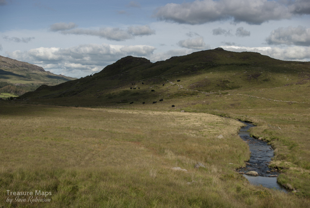
A ruined farm near one of the coal pits at "The Ballast"
The excellent booklet, produced by a local community initiative*, goes a very long way to redress the balance. It describes a series of walks not far from the aqueduct with just enough industrial archaeology to enable the visitor with half an imagination to join the dots for him or herself. The Tourist Office carries a dwindling supply of these booklets about the trail, which as far as I can see, is now out of print- a huge shame.
A glance at the Ordnance survey sheet for Cefn Mawr in 1904 will show a bewildering warren of tramroads, plateways, coal mines, foundries and countless other industries, none of which are remotely evident today, save as the odd retaining wall made from furnace slag or an alignment of road or footpath. Oh, for a time machine set at 1860.

And yet, there's something intensely pleasurable in taking in the genius loci, noting with a sudden thrill that the stone wall or abutment you have been looking at is actually one of the vestigial remains of a tramroad or a lime kiln.

Armed with one of the booklets supplied by the very helpful ladies of Trevor Basin TIC, Petra and I chose route D.

Interpretative Map by CreativityJones Design

I have to say that it was an eye-opener. We walked towards the north end of the Trevor basin, (3) on the map, past the truncated arm of the canal which once served the ironworks. It was an idyllic, bosky scene, and it didn't take much imagination to picture the place as it was a hundred years ago.

Then, the atmosphere changed. A large area of waste land resembling a bomb site opened up behind tall security railings on our right. High masts supported security cameras and lights, guarding the ransacked land where stunted, blighted birches and conifers were struggling to grow.
A far view of the Monsanto site from atop the Cefn Mawr ridge. Our route took us immediately in front of the tree line in the middle distance. The Vale of Llangollen is in the far background, and the aqueduct is just out of the photo to the left distance.


This was the Plas Kynaston estate, where several important industries sprang up in the 1800's to service the construction of the aqueduct. There were brickworks, potteries, engineering works, foundries and, notably, a chemical works which eventually grew to engulf the whole estate. Robert Graesser started an oil works here in the late 1860's to extract paraffin oil and wax from mining waste, later coal tar and explosives. He became so successful that he formed a partnership with the American chemical giant Monsanto. There were changes in ownership later to Flexsys, who closed most of the site and swept away the structures (and any remaining archaeology) but it has since been impossible to develop the area because of the very heavy chemical ground pollution.

There have been several plans mooted. The Plas Kynaston Canal Group want to re-open the canal and build a marina. Others suggest capping the site with concrete and building much-needed houses. There was even a suggestion that development could be funded by extracting the vast mineral wealth that supposedly lies below the site, although I don't see a modern quarry sitting well in a world heritage zone.

Putting those questions aside, we walked on, realising that the embankment to our left was the alignment of the Pontcycyllte Tramroad, a horse-drawn operation, later converted to accommodate steam locomotives. It eventually linked with the railway line to Llangollen, and some bridge abutments could be seen just before the A539 Llangollen Road. Along here on the left was once the mighty Trefynant Fireclay Works, owned by J.C.Edwards, who once supplied glazed terracotta bricks and tiles to the world. Edwards bricks decorated the Natural History Museum in London, as well as the fireplaces on the Titanic! The still new-looking produce of the  factory can be seen all through Cefn Mawr as many houses and shops are decorated with the shiny red bricks, made from local clay and fired with local coal.

photo: Petra Brown
We had to cross the A539 Llangollen Road, noting the Trefynant Pottery manager's house, built entirely from Terracotta bricks and tiles.


Once across the road, we took a public footpath alongside a stream, where informal gardens adjoined the opposite bank, Their walls were made from an impressive jumble of different tiles and bricks, something we would become used to seeing on our walk. Tiles marked "J.C.E" lay on the ground or half-buried everywhere along the path, as it passed the disturbed ground and overgrown tips of an old colliery, masked by woodland.

A tunnel was reached, under the disused Ruabon to Barmouth railway, closed in 1965. This is known locally as the "Darkie", as is the tunnel on the south end of the Pontcysyllte aqueduct.


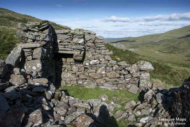
Once out of the tunnel, we encountered an old ruined building, half constructed in Sandstone and half in JCE bricks. Many structures in Cefn Mawr bear the marks of later alterations with local bricks like this. According to the booklet, this was a place known as the "Ballast", an open area pock-marked with vestiges of old pits, shafts and tips. We emerged into a beautiful meadow with many different species of wild flowers which Petra took delight in identifying. Some Vanner ponies were watching us from the top of a low spoil tip, but they must have known that we didn't have any sugar cubes or carrots, as to my disappointment,  they kept their distance.

We carried on and emerged, via some giant Lego bricks, into Bowers Road.


Bryn Terrace, seen in the above photo, was built in 1906 from...J.C. Edwards terracotta bricks. Bowers road was rather interesting in that we encountered some bridge abutments that looked to date from the mid-C19th. Later, when browsing early maps of the site, I discovered a reference to the road on an 1880 edition that had a tramroad from the Acre House colliery over the road to a tipping ground on the "Ballast". This area of Cefn Mawr is Acrefair and I wondered if the name came from Acre House farm nearby.


The Bowers Road tramway bridge abutments. Above the wall is a new road which, looking at Google Earth, obviously takes the line of the tramway formation. We carried on, following the booklet's map and found ourselves at the A539 again. There was once a large railway bridge at the junction, supporting the Ruabon to Llangollen Railway's line. This was removed in the 1960's. The nature of development here felt quite English; the houses for the most part made from local glazed brick with tile embellishments.


Our route now took us onto King street, where I spotted a likely sign...


Which led to this...


At first, I thought it might be an old station or a goods shed, but I realised that it was on the wrong alignment...the GWR line runs North West through here and this is slightly East North East. Looking at the booklet, it could be on the alignment of the GWR Pontcysyllte branch...I wonder...the two lines intersected  not far from here, the GWR Llangollen line crossing by a bridge over the Pontcysyllte.

We carried on to High Street, where there were more tiled and glazed brick homes. As the road gained height, stone buildings started to predominate, obviously settlement was older here, pre-dating the tile works. The structures were quite haphazardly built, too, few being square in plan, as if they were fitting into a plot. Many houses date back to when squatters were allowed to build their own homes here on the common land. Gradually, plots became fewer and increasingly odd shaped structures developed. We saw a few with dates like "1760" on the door lintels.

We reached the site of the Zion Chapel, where another mystery reared it's head.I can find no photos of this building before it was demolished, only references to members of the congregation in parish records. A memorial plaque on the wall behind the new house gives the date "1805". Behind, a memorial garden has been built, giving superb views out over the Plas Kynaston site to the Vale of Llangollen. There are some very fine tombstones in the cemetery; unfortunately the only seat has succumbed to the elements, so we perched on a wall to consume lunch, thinking of all those people buried here and what stories they could tell.


A little further along High street and we found the very fine building that is the former Grosvenor Inn.


The booklet recommended taking one of the many alleys and narrow wynds that abound here, down to King Street, where I had a sudden revelation. I realised that King Street was actually built on the alignment of the Pontcysyllte tramway, which would join with the "main line" at Acrefair. I don't think I would have understood this but for the excellent map in the booklet. The pathway was certainly narrow and steep.


We emerged into an area known as "The Crane", pretty much the centre of  Cefn Mawr, where roads converge in a haphazard but determined way. According to the booklet, the post office here is the actual site of "The Crane", which was used for hoisting or transferring waggons from one tramway to another at a different level. Or was it?
A report by Govannon Consultants for CADW suggests:
 "At the moment there is no firm evidence even to support the existence of a crane, let alone explain its purpose. There has also been a suggestion that the word ‘crane’ has nothing to do with the railway but is an Anglicization of a local Welsh dialect word, ‘craen’ or ‘y graen’, which means slope."

There are certainly plenty of those about here. We descended a steep one called "American Hill" which felt to me a little like a tramway incline, with a stone base at it's foot.

American Hill
The path was apparently named after a local man who made a large sum of money in the States, then returned and opened a shop. In 1849, perhaps?


The photograph from the nineteen thirties, above, shows "the Crane" site and also the route of King Street and American hill. No wonder we couldn't see any remains of the Plas Kynaston Pottery as we came down the hill - all that development on the left of the photograph is Monsanto Chemicals, where the pottery would have been.

We descended yet another tiny alley and dropped down to Queen Street where we took a trackway back to Trevor Basin, past a mothballed industrial plant, itself built over an old colliery shaft. I get the feeling that, like most post-industrial areas, Cefn Mawr would become more interesting in proportion to the time spent studying it. This time, we discovered more mysteries than we found answers for, but that's the thrill of the chase, isn't it?

"Cefn Mawr and District — Understanding Urban Character" superbly written Cadw Report available as a PDF

 * Very many thanks to the Cefn Mawr, Rhosmedre and Newbridge Community Association Ltd.

The Plas Kynaston Canal Group

 Limited copies of the booklet are available at The Tackle Shop, 5a Crane Street, Cefn Mawr LL14 3AB...thanks Steve!


Cwmorthin

$
0
0

I am lucky to live less than five minutes away from the car park, yet in the last ten years I have only visited Cwmorthin a handful of times.
Couple of years ago, the message boards of AditNow had been afire for five minutes because a new group had sprung up: Cofio Cwmorthin Remembered. They were an informal bunch of like-minded folk who wished to conserve and study the cwm. People as far away as Birmingham got very opinionated.  Footpaths were mooted, and interpretation boards.

There was a modest grant awarded to the group and some people had definite ideas on how that should be spent. The like-minded folk of Cofio Cwmorthin just got on with doing good things like conserving crumbling structures, making proper archaeological studies- and publishing what they had found on the web.


 I still didn't visit. The last time, it was a Sunday and I remembered that the place was crawling with folk in co-ordinated walking gear, camo-clad mine explorers and off-road trail bikers. There was no peace, as the two strokers tore up the silence like an unacceptable ransom offer. There were children, too, with their parents- enjoying the paths and exploring the old miner's houses, eating sandwiches and drinking pop. That last bit made me smile. Perhaps this old curmudgeon wasn't entirely turned to stone after all.

There's some good literature out there about the place. Jan Fortune, John Davies and the late Gwyn Thomas have all written poems about the cwm, evoking various interpretations and feelings. Every one of them left me with a particular image that resonated. There's Graham Isherwood's masterwork about the quarry and Lewis and Denton's magnum opus about Rhosydd, both as rare as hen's teeth, but worth selling the family silver for. Celia Hancock and M.J.T. Lewis have written a small but powerful history of Conglog Slate Quarry, at the end of the cwm. There's the excellent Cofio Cwmorthin website.

 So, one chill morning in the depths of winter, I took my camera out for a walk up there, thinking to take some shots in the bright unseasonal sunlight. There was nobody about. Just a few ravens and a farm dog freelancing up on the hill. Since then, I have been returning two or three times a week in different weather conditions, making up for ignoring the place, turning it into something of a project. Because there's no half measures with me, either I'm not interested, or I'm all over it.
So for the next year or so, interspersed with normal transmissions (and there are a lot of those, if I can just get round to finishing them) there will be articles and photos about various features of Cwmorthin.  A modest attempt, for better (or more likely worse), to document the place.
Cwmorthin sits like a drop of sunlit dew in a morning spider's web , a magical hanging valley above Tan y Grisiau;  deserted of human habitation but not of memories. Two-strokers  run out of fuel eventually, or get bored and go home. Everyone else has every right to enjoy the place and find whatever it means to them.

 Gwyn Thomas called it a "cup of loneliness". John Davies thought it "hung, cracked in Blaenau's draughty rafters" while to Jan Fortune, the "winds whined hymns that haunt the Sheepfold still..."

I might find out what it means to me.


The Chapels of Cwmorthin

$
0
0

Capel Rhosydd, seen from the Rhosydd tip.
The second of my occasional photographic wanders around Cwmorthin, this time focussing on the chapels. Yes, there are two!

The first needs no introduction and is almost, in the current parlance, an "iconic" feature. Capel Rhosydd (also known as Capel y Gorlan and Capel Conglog), is a gaunt shape sited by the track where the tramway diverts across the fields, behind a slate slab fence. It hasn't always looked so neglected. Many local folk  remember the chapel with a roof (some even profess to know who stole the slates).

Photograph of Capel Rhosydd in June 1995 by kind courtesy of Dave Linton.

Given that the quarrymen at Cwmorthin were for the most part a civilised, educated and god-fearing band of workers, it isn't surprising that a chapel was built for the families and children as well as the men themselves.  The building was paid for, not by the quarry company (of course not, why would they do that?) but by subscription from the men themselves, costing between two and three hundred pounds.


A school for the children of the quarrymen in the valley was founded in 1855 by Thomas Jones and Griffith Evans, based in Cwmorthin Uchaf farmhouse, although the accomodation was less than satisfactory. It found a permanent home at the chapel in 1867.


I won't plagiarise the excellent research done by Cofio Cwmorthin, but refer the interested reader to their site for much more detail on the chapel. Suffice to say that the chapel has appeared on book covers, calendars, numerous web sites and albums and is a much-loved landmark.

It's something of a milestone for me, as I usually have a cup of coffee from my flask, sitting in the shelter of the walls, when returning from an expedition in the cwm. On my most recent visit, I had intended to go up the flanks of Foel Ddu, and had followed a track marked on the map, going up the slopes to the north of the chapel. This was obviously a right of way remembered by the OS, but in 1890-  before Rhosydd had started tipping so energetically. By now, it had become more of a scramble/severe climb near the top.  At this point the wind was so fierce that I could hardly stand! I ended up wandering around the relative shelter of Rhosydd that day.


But back in the chapel on my return, I sat and savoured my flask of "Grumpy Mule",  listening to the wind howling round the walls. It was hard to imagine the bank of pews, or the minister giving a sermon amid the ruins and yet, there was something of an atmosphere. I've mentioned Jan Fortune's poems about the cwm before now, and her lines about the wind singing hymns in the walls was never more true. I felt somehow as if I had been granted asylum for a small time, out of the wind which was now becoming very strong indeed. A party of walkers passed outside, bent like soft alloy against the forces of nature, yet there I was, sipping coffee like a gent. Luckily, no stones fell off on me, and I walked out into the gale, the elements harrying me down the cwm and out to the car park for the short drive home.


The second chapel is an interesting one. It predates Capel Rhosydd by a year and was built to hold a hundred devout souls. It must have been a tight squeeze, because that seems an optimistic estimate to me. Capel Tiberias, as it was known, was an independent congregational chapel, built at the same time as the cottages of Tai Llyn, the barracks at the threshold of the cwm. There are no records as to how it was funded, but it was used by Cwmorthin and Wrysgan men and their families as far as I can ascertain. There is still a reasonably defined track leading to it and it holds a good position in a sheltered lee of the hillside. These days it is little more than a pile of stones and no photographs have yet been discovered showing how it might have looked during it's use.

Some Further reading:
Cofio Cwmorthin Remembered

Some interesting photographs on my learned colleague Alen Mcfadzean's blog, "Because they're there"

Slate Voices: Islands of Netherlorn and Cwmorthin by Jan Fortune and Mavis Gulliver, Cinnamon Press, ISBN 978-1-909077-24-9


A final shot from 1995, courtesy of Dave Linton

Keeping your powder dry

$
0
0
The Manod Powder Store with the tips of the modern quarry behind.
Of all the ancillary structures associated with mines and quarries, gunpowder magazines are, for me at least, among the most fascinating and most rewarding to locate.  They are usually sited a good distance away from the mine for safety reasons, and are often of a distinctive design.
Sometimes the magazine is an obvious feature, but more often than not, it has to be searched for among undergrowth and there is always a feeling of achievement when it has been identified!

The ruined powder house at Hafod y Porth, near Beddgelert.

The classic round powder store,  here at Hendre Ddu, Cwm Pennant
There seem to be a few designs that are repeated, probably due to their inherent fitness of purpose, but that still leaves room for a number of non-typical relics to be found. Probably most numerous, especially here in North Wales, is the round variety. These can be found everywhere mining took place.
The square or rectangular variety is also common, and is identified usually by it's lack of windows and flimsy roof.  (Usually completely rotted away by now). The walls were invariably lined with wood, presumably to guard against damp. The powder magazine at Manod (Bwlch Slaters) is a good example, the wood lining surviving despite the hellish weather conditions experienced in this cwm during winter. It was intended that, should there be an explosion, the blast would be directed upwards and would blow the roof off rather than reduce the walls to so much shrapnel!

The "new" magazine at Cwt-y-Bugail. This replaced an older one which was set in a defile next to the level A-B drumhouse.
The original magazine at Cwt-y-Bugail, which probably served the upper quarry before the mills at level B were built.
 Then there are the non-standard examples...most folk know about the "Beau Geste" fort powder store at Cwmorthin, now sadly lost (demolished by the quarry in the eighties), but there is an almost equally fascinating example at Penmaenmawr, with wing walls guarding it on the top of a promontory overlooking the sea.
Repurposed powder house at the New Pandora Mine, Gwydir

The very interesting structure at Penmaenmawr with outer protecting blast walls.
 There are a couple of "Keyhole" examples, most notably at Graig Ddu but also to be found elsewhere. With these types, there is an entrance porch usually cut into the ground, which leads to a small chamber where the explosives were kept. Imagine a heavy duty "igloo" shape made out of stone.

Moel y Gwartheg
The Cwm Teigl store...Chwarel Llew Twrog is just out of shot at top right.
Then there is the mysterious shelter in Cwm Teigl which experts attest is a hut with a vaulted roof...I think it is a powder store. It owes much to the keyhole pattern and has a roof vaulted with massive chunks of slate. It would only ever be big enough to crawl into, and is handy (as far as powder stores go) for Llew Twrog, Alaw Manod and Clogwyn y Garw mines.  Then there is the keyhole store at Moel y Gwartheg, although this may have been a shelter as there appear to be alcoves built into the walls.

The store at Nant Gefail y Meinars, sited well above the mine and buttressed against collapse (!)
Partly buried magazine at Brynglas, again well above the workings.
The collection of my photographs gathered here is by no means exhaustive coverage of the subject, nor is it the entire number of magazine shots I have in my files, but hopefully these will inspire others to go hunting for the elusive powder magazine!
Classic opportunistic design- a magazine with a freestone boulder as one of the walls! At Cwm Dwyfor copper mine.

Classic square magazine at Cefn Coch.
Square example at Cwm Cipwrth, with porch. This probably also served the nearby Gilfach copper mine.
Buried deep in the undergrowth - Gallt y Fedw, Dorothea.
Lastly, a rather primitive magazine partly buried at Bwlch y Ddeufaen West quarry.

Of Dylan, Copper and Slate

$
0
0
The intermediate drumhouse of the Cwm y Llan incline, looking towards the top. The Watkin Path bisects the incline as can be seen in the centre of the photo.
I first staggered up the Watkin path on a school field trip with ten other lads in the late 'sixties. They were a good bunch.  We'd been listening to the latest Dylan album on the coach (one of the lads had a new fangled cassette player with him). The album was the one with Dylan and Suze Rotolo on the cover..."Freewheeling Bob Dylan". With such epic tracks as Blowing in the Wind, and Masters of War.." the miles between Hyde Grammar and our digs at Plas Newydd just rolled on by as we considered the futility of war and how we'd never get suckered into going to 'Nam and fighting the "man's" war. Oh, yeah, we were hip cats, let me tell you, and the world was our oyster.

There was some discontent in our group when it became known that our master, Mr Metcalfe, expected us to climb halfway to the summit of Snowdon on this Watkin Path, to see some Moraines. We were young and creative- we could imagine them, couldn't we?  But Metcalfe was not someone to argue with, having a slightly menacing persona reminiscent of Lee Marvin, so we grudgingly assented. There was much talk about glaciation and drumlins from the Metcalfe, when I spotted the lofty Cwm y Llan incline towering above- and asked our mentor what it was all about.
The lads weren't interested and larked about, but something had got hold of me- and as Metcalfe explained the tramway and incline system, the seeds of an unhealthy life-obsession with quarries and mines were sown. The rest of that day was spent in wonder at the remains of the tramway and mines of the cwm, to the other boys amusement. And it did take the heat off them, as I kept asking Metcalfe about various features.

A bridge remains where the incline shot over a track, now repurposed as the popular route to Snowdon.
Fast forward a lot of years. It's January, and Petra and I are walking up the Watkin Path, dodging out of the way of technically clad walkers, hell bent on summit glory. Our mine gear must have looked strange to them but they wish us hearty "Good Mornings" as they yomp past carrying the human equivalent of HGV loads in their rucksacks.  We're only planning on looking at a couple of mines on the lower slopes, yet even here, there is enough stuff to require at least two blog posts.

The Incline belongs to a derelict concern called the Hafod y Llan slate Quarry, or South Snowdon...the actual quarry nestles in a wild region uphill called Cwm Tregalan, where it seems, much weather originates. The quarry was part of a group of concerns that employed some creative accounting in order to justify their meagre returns on capital. Certainly it must have cost a great deal to build the incline and tramway works, let alone dig the holes in the cwm. The late Gwynfor Pierce Jones, doyen of Welsh Slate experts, calls the tramway and incline "heroic" and I wouldn't dream of arguing with that.

Our first impressions, walking up the Watkin path, were of the incline and it's soaring flight from high above. It rivals the Wrysgan incline for length and steepness, although without the tunnel at the top. We were to explore the drumhouse later, but the first thing that caught our attention was the processing area of the copper mine, also called "Hafod y Llan". This was an old mine before the 1840's, when well-known quarry wrangler Alan Searell took over the management.  Ore was sold at Swansea in 1825/6, for instance. The layout of the mine was unorthodox to say the least. Copper was mined from high up on the hill, a flank of Y Lliwedd. The stoping can be seen from the Watkin Path. A tramway took the ore along to a point above the processing works, where it was thrown down a chute!
The Copper mine, with the top platform of the chute, high above.
Searell was eventually to admit that the mine frustrated him. He wrote in April 1862 to Henry McKellar, the leasee,  that "I have no confidence in my own judgement in mining, I really do not understand it, for it rarely turns out the way I expected". This was a man who had given his life to mining enterprises, constantly working to raise saleable ore, or finance further exploration.
Searell did not lead an easy life, often on the go from 5 am in the morning until late at night, riding or walking between mines without rest- and was responsible for more than a few miners keeping their jobs.

Of the processing floor, there were waterwheels, stone crushers and ancillary equipment. The pit for a waterwheel can still be seen next to the building across from the waterfall. A curious stone block railway leads from here, across the river and up to Braich yr Oen copper mine, another one of Searell's charges. It reminded me more of the Haytor granite tramway than anything in Wales. The gauge is nominally four feet, perhaps a little more- certainly unique in Welsh copper mining. It is a mystery, beginning just at the trackbed of the Slate quarry tramway above. The mine itself is a couple of hundred feet further up the mountain. We aim to take a further look at this, so will report our findings in another instalment.

The stone block tramway
And so to the lower end of the South Snowdon tramway, which winds most scenically down the cwm from the ferocious weather uphill. The trackbed is still pleasant walking, if a little boggy in places and the formation is well revetted and engineered. Cuttings have been blasted along the way. From what I can glean from the various accounts of the quarry, it was hoped that a railway branch would be laid to join with the WHR and onward to Porthmadog. Of course this never happened, and carts took the slate or ore from the bottom of the incline. Ironically, there is still a wharf at Porthmadog called "South Snowdon", yet it is a very long time since it saw any slate from Cwm y Llan!

The top incline drum house looking down to Nant Gwynant
The view from the top
The whole enterprise, the incline, tramway and mine workings strike one as some kind of quixotic feat, misguided and perilous. Yet, there are these remains, noble and striking in their compass of nature and engineering. The works are for the most part drystone and engineered so well that much still stands, despite being situated at such a height and in a place known for it's wild weather. I'm delighted to re-acquaint myself with the place.


I owe old Metcalfe a great deal, as he encouraged me and gave me some very hard kicks up the butt as and when required to get me back on the rails. I never thanked him, even though I appreciated his gimlet eye on my school career. He's probably scratching away on that blackboard in the sky now, but for what it's worth, thanks Mr M.

He'd probably smile and say "Don't think twice, it's alright"...

Next time, the tramway to South Snowdon Slate...


Moving On...

$
0
0

I'm migrating away from Blogger. It's been a good spell, seven years on this platform, but nothing stays the same for long on the internet and I feel I've outstayed my welcome. Google appear to be wondering what to do with Blogger and to be honest, it has become more unwieldy and difficult to use for a while now. Comments not working was the last straw.
But "Treasure Maps" is not dead, I will be on my own, new platform and will be re-posting everything worth re-posting from here...eventually! So stories of my stumbling about and being kept right by Petra will continue, you don't get away that easily!

The new site is here  Treasure Maps  

 I will keep the mothballed Blogger site up indefinitely as a resource, if I can be so pompous to call it that :-)

The new site will be more in-depth and feature more photos and albums, in pale imitation of the two best I.A. sites out there, Dave Sallery's Penmorfa and JAW.

So...thanks for viewing, for all your support and comments, your letters, and suggestions, all hugely appreciated. I hope to see you over at "son of"Treasure Maps  soon!


Closely Observed Blondins

$
0
0

I took another, closer look at the remaining aerial ropeway equipment in a certain North Wales quarry last weekend.  I was fortunate to be accompanied by industrial photographer deluxe, Andy Marland, whose "Mechanical Landscapes" blog and web site has long been one of my favourite inspirations. It's great sharing somewhere special with another like-minded person - but it was also fascinating to see how we individually approached the photographs. Despite my having quartered the site very thoroughly before, Andy saw quite a few new angles (and new artifacts). His shots give a very good feel for the site and it's unique atmosphere, despite us having to leave before being able to cover all the goodies on offer.


It's such a significant site, in a stunning location - but it has to be said that the weather was against us. I know what you're thinking, but no,  it wasn't rain that was the problem, rather the opposite- brilliant March sunshine. It was difficult not to lose mid-tones or blow whites and I found myself seeking the peace and decorum of the winding houses to take some suitably sober (and dark!) photos.


Many of the buildings face west and the one remaining Blondin pylon was not particularly well placed against the sun- the challenge was also to trade off the intense light against the gloom of the interiors and still retain detail. It was huge fun, although I took the fainthearted way out, going for a more intimate portrayal of the winders. For Andy's very fine record of the visit, take a look at his   excellent "View from the North" site. His Pen-yr-Osedd set is here.

It just remains to thank Andy for his excellent company and for giving me the justification to visit this lovely place again.


 I am afraid that I have to say access is not encouraged at the quarry, quite the opposite as it is a dangerous and sensitive site with blasting going on during the week. Permission should be sought -and at the very least, the site should be treated with a great deal of respect and care.


Viewing all 103 articles
Browse latest View live