![]()
We have wanted to look at these mines for many years, but were always put off by the inhospitable terrain. The thought of slogging for hours only to find a few scrapings on the ground didn't seem a sensible pursuit. So what had changed our minds? Well, we had been exploring the mountains around the Lledr Valley and found that it was quite possible to make good progress by sticking to the tops and flanks of the peaks. Coming from the Crimea pass, it's possible to get a good start by using the Tunnel road to the ventilation shaft workings. The trouble is, most of the mines are at the bottom of valleys.
![]()
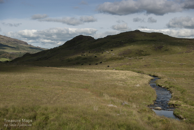
After a lot of map study, we elected to go up from the Hendre Coed slate mine, following the river all the way up. (SH69655 51231) It wasn't too bad initially, as a farm road goes for a few hundred yards. We crossed the river at the old bridge, finding the tracks of the farmer's quad bike also went our way...so far, so good. Incidentally, this bridge and the ruined buildings around it (SH68701 50298) seem to be shrouded in mystery. Geograph states that they belonged to the Moel Fleddiau slate mine...really? Since that mine lies on the bwlch between the Lledr watershed and Allt Fawr, and it is a short step to Blaenau ( a rather precipitous one, admittedly) I have my doubts...surely the mule track over Bwlch-y-Moch would be more reasonable. At any rate, on the OS 1888 map, bridge and buildings are referred to as Cwm Fanhadlog Uchaf and on the modern series, Cwm Fynhadog Uchaf .
![]() |
| The bridge over the Lledr by Cwm Fynhadog Uchaf, clearly of some antiquity. |
One of the structures has the look of a chapel about it...I came this way several years ago and took photos but can't remember if there were any gravestones...this time the bracken was too high for exploration, but perhaps this was a chapel for the workers on the tunnel? Across and further up the hillside above the bridge is a powder house for the tunnel.
![]() |
| Moel Siabod glimpsed behind the mystery building at Cwm Fynhadog Uchaf. |
We walked on. I was wearing a brand-new pair of boots and they were performing well, my last ones having disintegrated due to constant soakings. We came to a flat area where the pasture resembled a prairie, and here, the quad bike trail ended. Now the ground ramped up and became much more inhospitable. To describe the rest of the walk I can do no better than to quote the
Walk Highlands web site, which states:
"following the river up the valley is probably the wettest stretch of walking imaginable, a long, long slog of waist-high reeds hiding knee-deep watery marsh…"That's the one. If someone had been watching as we stumbled and slipped from one bog to the next, or pratfalled countless times, they would have been highly entertained. Gaining height simply changed the predominant vegetation to chin-high ferns, but still with the knee deep bog and with the added delight of sheep ticks. Every now and then, a rock outcrop was encountered, providing a welcome respite from the bog-bumping and falling over.
Petra spotted a small building, not immediately visible on Google Earth, right beside the river. It was a wal, with a modest waste tip alongside. (SH68112 49396) The small excavation went into an outcrop beside the river and must have been a trial. It made a nice photo, but it seems to have escaped the cartographers, as it is not marked on any map or survey, including the OS 1880 from the NLS.
However, we were emboldened now. Despite our pitifully slow progress, I reckoned we would be at the Afon Lledr mine in 35 mins. The next half mile was the longest and most painful of my life, but we made it. Perhaps it would have been easier in the winter, when the vegetation is not so high and the ground frozen...who knows.
![]() |
| The Afon Lledr spoil heaps. |
The site of the mine is a very interesting one, comprising two possible concerns. The original Afon Lledr mine is nominally copper, and crosses the stream to a low adit, flooded to the ceiling and with deadly silt in the entrance. This would appear to date from the early to mid C19th as again there is no record of it being other than disused on the 1880 OS survey. The waste tips contain some fine chumks of quartz and galena. The mine is at SH67559 49299.
![]() |
| The Lower Adit |
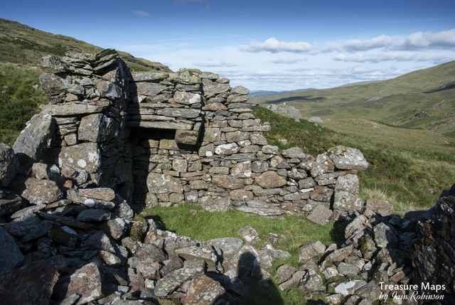
Further upstream there are some ruined buildings and three opencuts, plus a flooded shaft. The buildings are a fine range and as far as I can tell, comprise a forge, a barracks and an office. Processing seems to have gone on in the open air. The first opencut goes west, then turns at right angles upon encountering the lode. A fairly deadly-looking winze chases the lode further and lower.
![]() |
| Remains of the forge |
Another opencut is worked above and finally at the top of the outcrop, there is an opencut with a flooded shaft. As far as I can tell, these are the workings of the Moel Fleiddiau lead mine, although all the mines here are thus marked on the OS.
![]() |
| The processing area and office at Afon Lledr. |
By now, the sun was due west and photography was difficult from some angles, hence my photographs of the workings are not as fine as I would have liked. However, this is a fascinating spot, well worth the crippling walk. We found no sign of the features in the stream that David Bick writes about in his "Copper Mines of Snowdonia" although the mine fits the bill in every other respect. And the new boots? They are still drying out.
![]() |
| The winze. |
Further reading: "The Old Copper Mines of Snowdonia" by David Bick, ISBN 0 906885 03 5